|
| Mesoscale Discussion 45 |
|
< Previous MD Next MD >
|
|
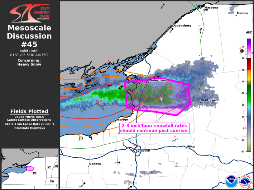
   Mesoscale Discussion 0045
   NWS Storm Prediction Center Norman OK
   1030 PM CST Mon Jan 20 2025

   Areas affected...portions of far western New York

   Concerning...Heavy snow

   Valid 210430Z - 211030Z

   SUMMARY...At least 2-3 inch/hour snowfall rates should continue past
   sunrise with an intense lake-effect snow band.

   DISCUSSION...MRMS mosaic and KTYX radar imagery show an intense,
   steady-state lake-effect snow band persisting across Jefferson and
   Lewis Counties in far western NY. This snow-band is benefiting from
   an optimal fetch of moisture off of Lake Ontario, where 8+ C/km 0-3
   km lapse rates are in place. As such, convective snowfall within
   this lake-effect band should persist past sunrise, as shown by the
   latest high-resolution guidance consensus. Furthermore, given the
   convective nature of the band, and degree of saturation in the
   dendritic growth zone, snowfall rates at least in the 2-3 inch/hour
   range are expected through the remainder of tonight.

   ..Squitieri.. 01/21/2025

   ...Please see www.spc.noaa.gov for graphic product...

   ATTN...WFO...BUF...

   LAT...LON   43977634 44027567 43947519 43697514 43547540 43587581
               43617612 43647630 43977634
|
|
Top/All Mesoscale Discussions/Forecast Products/Home
|
|


 @NWSSPC