|
| Mesoscale Discussion 44 |
|
< Previous MD Next MD >
|
|
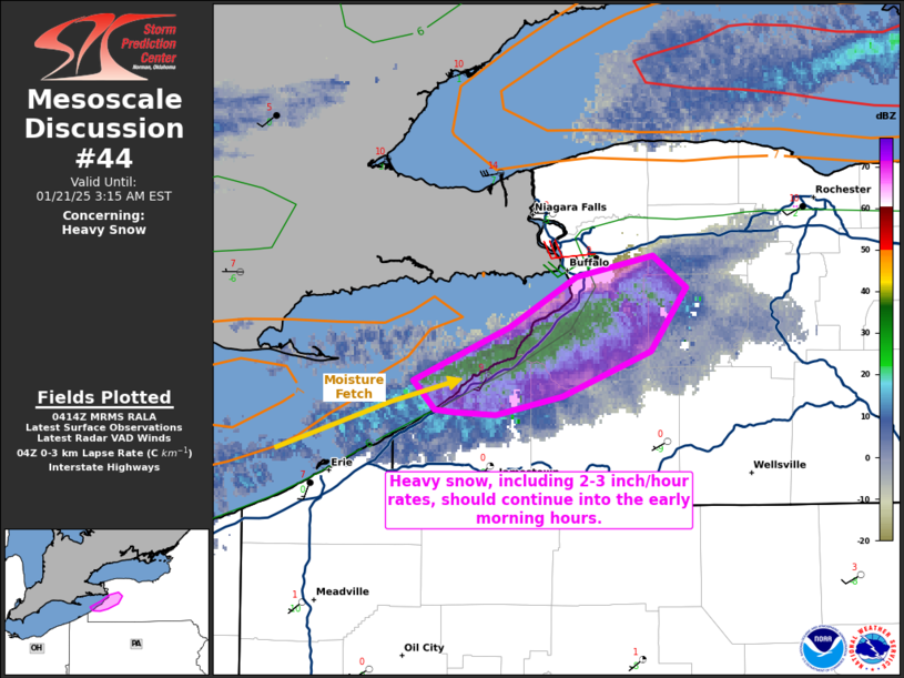
   Mesoscale Discussion 0044
   NWS Storm Prediction Center Norman OK
   1016 PM CST Mon Jan 20 2025

   Areas affected...portions of far western New York

   Concerning...Heavy snow

   Valid 210416Z - 210815Z

   SUMMARY...Heavy lake-effect snow should continue into the early
   morning hours, with 3 inch/hour intermittent snowfall rates likely.

   DISCUSSION...The lake-effect snow-band has taken a more
   southwest-to-northeast orientation over the past hour or so, with
   heavy snow recently reported as far south as the Dunkirk Airport.
   04Z mesoanalysis shows increased boundary-layer convergence and
   moistening along a northern Chautaugua to Erie County line, which
   will support continued heavy snowfall rates within the main band.
   Snowfall accumulations over very short time periods via reports
   suggest that near 3 inch/hour snowfall rates may be occurring with
   this snow band. With the 04Z mesoanalysis showing 7.5 C/km 0-3 km
   lapse rates present over water (where a long moisture fetch is in
   place), 2-3 inch/hour snowfall rates may continue into the early
   morning hours, as also suggested by latest high-resolution guidance
   consensus.

   ..Squitieri.. 01/21/2025

   ...Please see www.spc.noaa.gov for graphic product...

   ATTN...WFO...BUF...

   LAT...LON   42467965 42677916 42857882 42937844 42827827 42577845
               42407890 42337923 42357944 42357954 42467965
|
|
Top/All Mesoscale Discussions/Forecast Products/Home
|
|


 @NWSSPC