|
| Mesoscale Discussion 2181 |
|
< Previous MD Next MD >
|
|
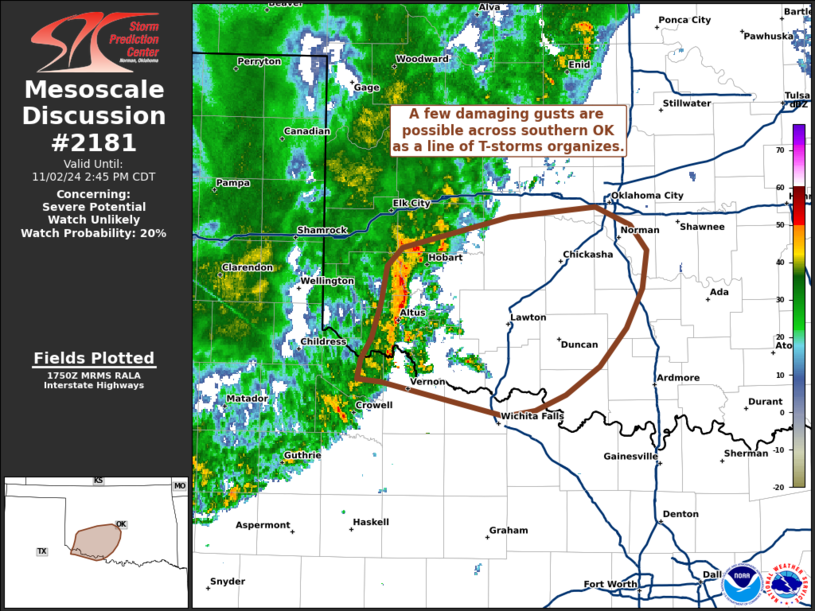
   Mesoscale Discussion 2181
   NWS Storm Prediction Center Norman OK
   1252 PM CDT Sat Nov 02 2024

   Areas affected...Southern Oklahoma

   Concerning...Severe potential...Watch unlikely

   Valid 021752Z - 021945Z

   Probability of Watch Issuance...20 percent

   SUMMARY...A few damaging wind gusts will be possible across southern
   OK heading into the afternoon hours as a line of T-storms continues
   to organize.

   DISCUSSION...Over the past hour, a weak line of convection across
   southwest OK has shown signs of increasing organization/intensity in
   the form of a consolidating/more balanced outflow and increasing
   VIL/VII values and lightning counts. Downstream, continued low-level
   theta-e advection into southern/central OK is promoting MLCAPE
   values up to around 500 J/kg per recent mesoanalysis estimates, and
   the KFDR VWP is sampling 0-3 km BWD values of around 30 knots with
   shear vectors oriented largely orthogonal to the line. These
   convective and environmental trends suggest that further
   intensification of the line is possible with an attendant increase
   in damaging wind potential in the coming hours. However, extensive
   cloud cover will likely modulate overall destabilization of an
   already spatially limited warm sector across southern OK, which
   should limit convective intensity. Trends will continue to be
   monitored, but this line is not expected to reach sufficient
   intensity to prompt a watch issuance.

   ..Moore/Smith.. 11/02/2024

   ...Please see www.spc.noaa.gov for graphic product...

   ATTN...WFO...OUN...

   LAT...LON   34369966 34519958 34769949 35029945 35149932 35369840
               35449765 35309736 35129721 34869726 34589739 34309763
               34109792 33999817 33959843 34199950 34219969 34369966
|
|
Top/All Mesoscale Discussions/Forecast Products/Home
|
|


 @NWSSPC