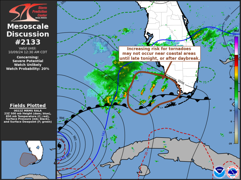
   Mesoscale Discussion 2133
   NWS Storm Prediction Center Norman OK
   0723 PM CDT Tue Oct 08 2024

   Areas affected...southwestern coastal Florida and the lower Keys

   Concerning...Severe potential...Watch unlikely

   Valid 090023Z - 090530Z

   Probability of Watch Issuance...20 percent

   SUMMARY...Supercell development posing risk for
   waterspouts/tornadoes is possible offshore of southwestern Florida
   coastal areas and north of the lower Keys much of tonight.  It
   appears that this may not spread into coastal areas and inland until
   closer to or beyond daybreak.  However, trends are being closely
   monitored.

   DISCUSSION...A weak/diffuse surface frontal zone in advance of
   Hurricane Milton has been a focus for persistent discrete rotating
   storms the past several hours, roughly 50-150+ miles north-northwest
   through west of the Key West vicinity.  This activity has likely
   been supported by forcing for ascent associated with weak low-level
   warm advection and moderate to strong southwesterly deep-layer
   shear.  Low-level hodographs are likely rather modest to weak, but
   clockwise curved, and in the presence of seasonably high
   boundary-layer moisture content this probably has been sufficient to
   support low-level mesocyclones occasionally producing waterspouts.

   Through late evening and into the overnight hours, as Milton slowly
   accelerates northeastward across the southeastern Gulf of Mexico,
   the developing warm frontal zone probably will begin to surge
   northward to its immediate north and northeast.  However, closer to
   southwestern Florida Peninsula coastal areas, the Rapid Refresh
   suggests that the boundary may remain quasi-stationary into early
   portions of the overnight hours, and may not begin approaching the
   Naples/Fort Myers vicinities until 09-12Z.  Even at that time,
   low-level hodographs may only just be in the process of modest
   enlargement, as flow around 850 mb becomes southeasterly and begins
   to increase in excess of 30 kt.  And, based on forecast soundings,
   appreciable boundary-layer destabilization may not develop inland of
   coastal areas until after daybreak.

   ..Kerr/Edwards.. 10/09/2024

   ...Please see www.spc.noaa.gov for graphic product...

   ATTN...WFO...MFL...KEY...

   LAT...LON   25238364 25588350 26158314 26078224 25848148 25408105
               24968121 24668212 24248280 24538355 25238364
|


 @NWSSPC