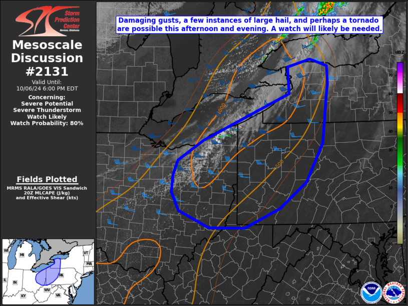
   Mesoscale Discussion 2131
   NWS Storm Prediction Center Norman OK
   0326 PM CDT Sun Oct 06 2024

   Areas affected...eastern Great Lakes

   Concerning...Severe potential...Severe Thunderstorm Watch likely

   Valid 062026Z - 062200Z

   Probability of Watch Issuance...80 percent

   SUMMARY...Damaging gusts, a few instances of large hail, and perhaps
   a tornado are expected this afternoon across parts of the eastern
   Great Lakes. A watch will likely be needed in the next hour or two.

   DISCUSSION...A band of deepening convection is evident across parts
   of northeast Ohio and southern Ontario near a surface cold front and
   a cyclonically curved mid-level jet. These features should provide
   lift for continued convective development as the afternoon
   progresses. Heating has warmed parts of the area into the upper 70s
   to low 80s, and continued moist advection has increased dewpoints
   into the upper 50s, resulting in 1000-2000 J/kg SBCAPE per
   Mesoanalysis and a 20Z sounding from PBZ. The impinging mid-level
   jet results in 35-45 kts of effective bulk shear, which ought to be
   sufficient for supercells with the initial development. Given a
   supercellular mode and 7.7 C/km 2-6 km max lapse rates on the 20Z
   PBZ sounding, some hail is possible early. A tornado is also
   possible given 150 m2/s2 0-1 km SRH, though this may be mitigated by
   higher LCLs, especially across eastern Ohio. In addition, storms may
   be undercut by the cold front, which is expected to lead to upscale
   growth into linear segments with time. Once this transition occurs,
   given strong low-level flow, damaging gusts will become the primary
   threat as storms move to the east. The eastward extend of the severe
   threat may be mitigated by the narrow plume of moist air combined
   with loss of daytime heating this evening.

   ..Supinie/Smith.. 10/06/2024

   ...Please see www.spc.noaa.gov for graphic product...

   ATTN...WFO...BUF...CTP...PBZ...CLE...ILN...

   LAT...LON   41537797 40667847 40077925 39638029 39638134 40018223
               40438246 40838242 41148228 41618152 42657896 43267899
               43427832 43277781 42877779 42567784 41537797
|


 @NWSSPC