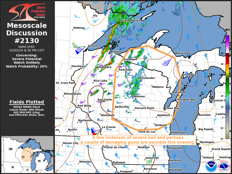
   Mesoscale Discussion 2130
   NWS Storm Prediction Center Norman OK
   0706 PM CDT Sat Oct 05 2024

   Areas affected...portions of northern and eastern Wisconsin into
   western Upper Michigan

   Concerning...Severe potential...Watch unlikely

   Valid 060006Z - 060130Z

   Probability of Watch Issuance...20 percent

   SUMMARY...Thunderstorms should increase in coverage and organization
   this evening. A few instances of severe hail and perhaps a couple of
   damaging wind gusts are possible.

   DISCUSSION...Thunderstorms are developing ahead of an approaching
   cold front over western WI, as deep-layer ascent from a rapidly
   approaching upper trough and 700 mb CAA overspreads the Upper MS
   Valley. Ahead of the cold front, Surface-850 mb WAA supports
   marginal destabilization across Wisconsin into Upper MI, with
   500-1000 J/kg MUCAPE noted per 23Z mesoanalysis. Strong tropospheric
   wind fields are in place, with 35-50 kts of southerly 925-850 mb
   flow overspread by 60+ kts of westerlies at the mid-levels,
   contributing to 50-70 kts of effective bulk shear. Strong
   directional wind shear in the 925-500 mb layer supports large,
   curved hodographs and the associated potential for supercell
   structures.

   Nonetheless, buoyancy is scant, largely due to modest low-level
   moisture, with most of the aforementioned MUCAPE constrained well
   above 700 mb (per latest RAP forecast soundings). Furthermore,
   appreciable MLCINH remains in place. While strong forcing and shear
   support storm organization, limited buoyancy suggests that most
   storms, including any supercells that materialize, will likely be
   elevated in nature. Some potential for severe hail exists given
   strong wind shear coinciding with 7-8 C/km mid-level lapse rates,
   and a damaging gust or two also cannot be ruled out. Overall, the
   severe threat may remain isolated through the evening and overnight
   hours.

   ..Squitieri/Kerr.. 10/06/2024

   ...Please see www.spc.noaa.gov for graphic product...

   ATTN...WFO...MQT...GRB...MKX...DLH...ARX...

   LAT...LON   44179069 45999056 46738987 46908886 46438743 45708714
               44658727 44048766 43818831 43788943 44179069
|


 @NWSSPC