|
| Mesoscale Discussion 2122 |
|
< Previous MD Next MD >
|
|
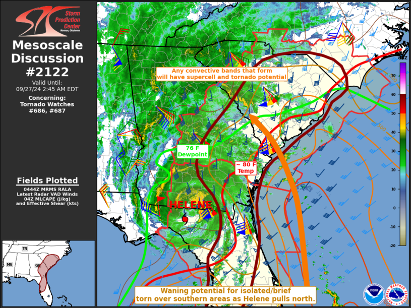
   Mesoscale Discussion 2122
   NWS Storm Prediction Center Norman OK
   1146 PM CDT Thu Sep 26 2024

   Areas affected...northern Florida into the Carolinas

   Concerning...Tornado Watch 686...687...

   Valid 270446Z - 270645Z

   The severe weather threat for Tornado Watch 686, 687 continues.

   SUMMARY...The environment remains conditionally favorable for
   supercells producing tornadoes, primary over southeast Georgia into
   South Carolina.

   DISCUSSION...Unstable air continues to wrap northwestward ahead of
   Helene, with the high theta-e air mass now inland across eastern SC
   and GA. Very strong gusts continue into the Jacksonville FL area
   within the well-mixed boundary layer where temperatures are in the
   80s F. Dewpoints are also averaging 78- 80 F along the coast farther
   north.

   While severe cell coverage has decreased compared to a few hours
   ago, conditions remain quite favorable for tornadoes should
   additional bands of storms form. This is quite possible through
   tonight as low-level flow remains confluent. In addition, the high
   dewpoints will easily favor development with relatively minimal
   lift. As such, the tornado watch will continue from GA into southern
   NC for some time.  Areas to the south into central FL should
   eventually see a waning threat as convergence weakens due to the
   system pulling rapidly north.

   ..Jewell.. 09/27/2024

   ...Please see www.spc.noaa.gov for graphic product...

   ATTN...WFO...RAH...ILM...CHS...CAE...MLB...GSP...TBW...JAX...
   FFC...TAE...

   LAT...LON   30798131 29768122 28258158 27838200 27628254 27748280
               28178285 28728277 29328280 29878249 30448244 30998268
               31528316 32148319 32758283 33418224 34238159 34678111
               34888007 34767914 34477855 33857838 33507889 33057918
               32557994 32148048 31728102 30798131
|
|
Top/All Mesoscale Discussions/Forecast Products/Home
|
|


 @NWSSPC