|
| Mesoscale Discussion 2108 |
|
< Previous MD Next MD >
|
|
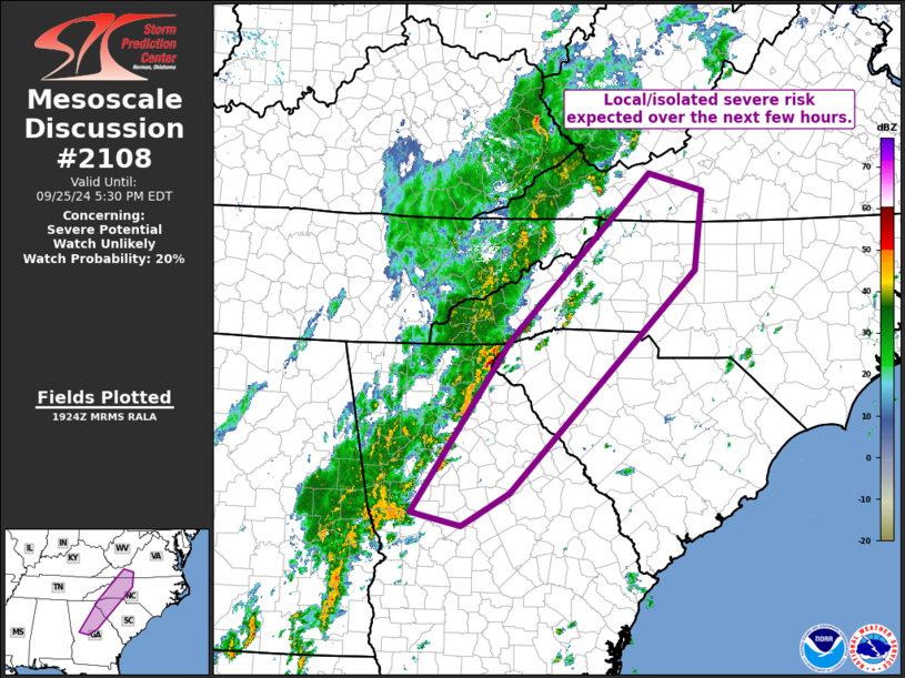
   Mesoscale Discussion 2108
   NWS Storm Prediction Center Norman OK
   0226 PM CDT Wed Sep 25 2024

   Areas affected...southwestern Virginia and the western Carolinas to
   central Georgia

   Concerning...Severe potential...Watch unlikely

   Valid 251926Z - 252130Z

   Probability of Watch Issuance...20 percent

   SUMMARY...Isolated strong storms -- a few of which reaching severe
   levels -- are expected near and east of the higher terrain of the
   Appalachians.  All-hazards severe risk -- including a brief tornado
   or two -- will be possible with the strongest of these storms, but
   coverage of the more substantial convection may preclude the need
   for WW issuance.

   DISCUSSION...Latest visible satellite imagery shows high cloudiness
   expanding across the pre-frontal warm sector at this time, though
   until now, ample heating has resulted in modest destabilization
   (around 1000 J/kg mixed-layer CAPE) near and just ahead of the
   slowly advancing cold front.  Convection continues to gradually
   increase across the area, with one particularly organized storm now
   affecting the Habersham/Rabun County Georgia area, and -- soon --
   portions of Oconee County South Carolina.

   The somewhat modest warm-sector CAPE is being partially offset -- in
   terms of potential for robust convection -- by relatively strong
   southwesterlies at mid levels southeast/east of the upper low near
   the confluence of the Ohio and Mississippi Rivers.  This flow, atop
   low-level southeasterlies, is providing shear sufficient for both
   mid-level and -- to some degree -- low-level rotation.  Though
   overall coverage of the more robust storms is expected to remain
   limited, the area bears watching given the favorable kinematic
   environment.  While current expectations are that a WW will not be
   required, we will continue to monitor convective evolution and
   possible/additional destabilization this afternoon.

   ..Goss/Guyer.. 09/25/2024

   ...Please see www.spc.noaa.gov for graphic product...

   ATTN...WFO...RAH...RNK...CAE...GSP...MRX...FFC...

   LAT...LON   32858455 35038307 37168089 36938007 35928020 33098306
               32678379 32858455
|
|
Top/All Mesoscale Discussions/Forecast Products/Home
|
|


 @NWSSPC