|
| Mesoscale Discussion 2109 |
|
< Previous MD Next MD >
|
|
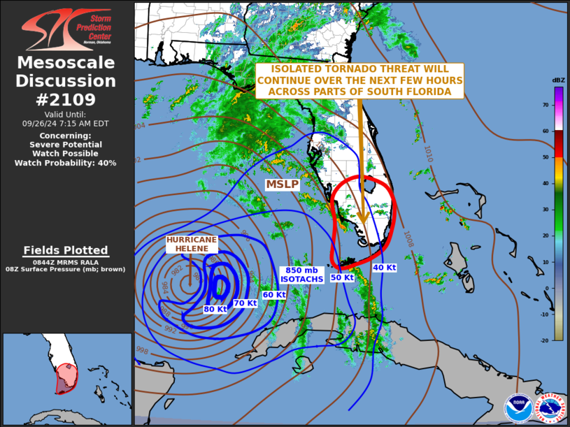
   Mesoscale Discussion 2109
   NWS Storm Prediction Center Norman OK
   0346 AM CDT Thu Sep 26 2024

   Areas affected...South Florida

   Concerning...Severe potential...Watch possible

   Valid 260846Z - 261115Z

   Probability of Watch Issuance...40 percent

   SUMMARY...An isolated tornado threat will continue across parts of
   south Florida over the next few hours. Weather watch will be
   possible at some point this morning.

   DISCUSSION...Hurricane Helene is currently located over the eastern
   Gulf of Mexico, with the outer rain bands extending to near the west
   coast of south Florida. The latest hi-resolution radar imagery from
   Miami shows widely spaced discrete storms ongoing along and near the
   Florida Gulf Coast. The WSR-88D VWP at Miami has 0-6 km shear around
   35 knots, with 0-3 storm-relative helicity near 275 m2/s2, which is
   pretty similar to what was evident on the 06Z sounding at Miami.
   This will be favorable for storm rotation and potentially tornado
   development within the cells that obtain supercell structure. RAP
   forecast soundings across south Florida slowly strengthen low-level
   shear this morning, and have a gradual increase in instability. This
   suggests that the tornado threat will be maintained across south
   Florida. Additionally, a band of storms has developed to the south
   of the Florida Keys over the last couple of hours. As this band of
   storms spreads northward into south Florida this morning, the
   tornado threat may increase.

   ..Broyles/Gleason.. 09/26/2024

   ...Please see www.spc.noaa.gov for graphic product...

   ATTN...WFO...MFL...MLB...KEY...TBW...

   LAT...LON   25708005 26147999 26528003 26928031 27178098 27108143
               26878182 26488202 25838192 25228197 24738201 24518184
               24498160 24588130 24798075 25138027 25708005
|
|
Top/All Mesoscale Discussions/Forecast Products/Home
|
|


 @NWSSPC