|
| Mesoscale Discussion 2107 |
|
< Previous MD Next MD >
|

|
   Mesoscale Discussion 2107
   NWS Storm Prediction Center Norman OK
   0305 AM CDT Wed Sep 25 2024

   Areas affected...Dallas/Fort Worth Metroplex

   Concerning...Severe potential...Watch unlikely

   Valid 250805Z - 251000Z

   Probability of Watch Issuance...20 percent

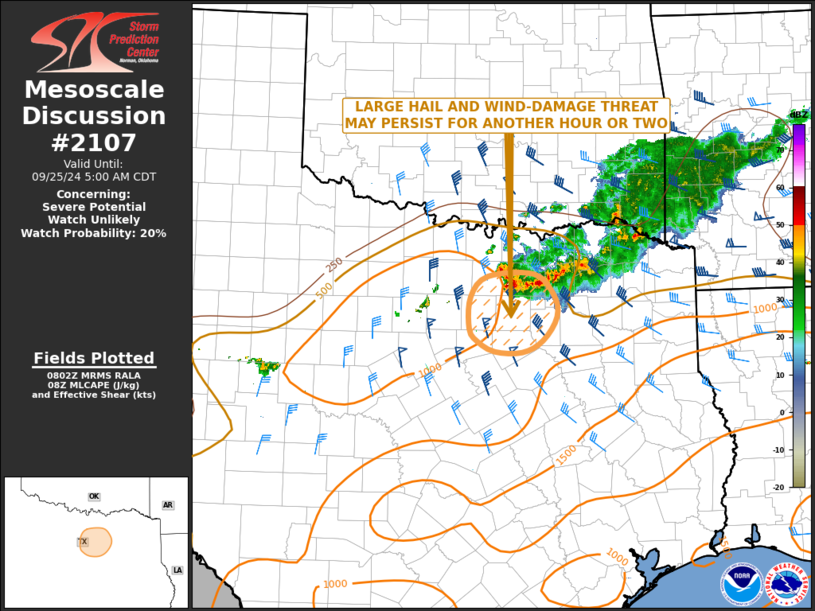
   SUMMARY...An isolated large hail and wind-damage threat may persist
   for another hour or two as a small complex of storms moves into the
   Dallas/Fort Worth Metroplex. The severe threat area is expected to
   remain small, and watch issuance is not expected.

   DISCUSSION...The latest high-resolution radar imagery shows a small
   cluster of strong to severe storms located just to the north of the
   Dallas/Fort Worth Metroplex. RAP analysis suggests that the airmass
   is moderately unstable with MLCAPE around 1000 J/kg. The latest
   WSR-88D VWP from Fort Worth has 0-6 km shear near 45 knots, with
   gradually veering winds in the low to mid-levels. In addition, RAP
   forecast soundings have steep mid-level lapse rates around 700 mb.
   This should be enough to continue an isolated large-hail threat with
   transient supercell structures embedded in the cluster. An isolated
   wind-damage threat may also accompany the leading edge of the more
   intense cells. The threats are expected to continue for another hour
   or two.

   ..Broyles/Leitman.. 09/25/2024

   ...Please see www.spc.noaa.gov for graphic product...

   ATTN...WFO...FWD...

   LAT...LON   33259646 32999616 32719612 32419633 32279664 32279704
               32409731 32569742 32969741 33239715 33259646
|
|
Top/All Mesoscale Discussions/Forecast Products/Home
|
|


