|
| Mesoscale Discussion 2106 |
|
< Previous MD Next MD >
|

|
   Mesoscale Discussion 2106
   NWS Storm Prediction Center Norman OK
   0810 PM CDT Tue Sep 24 2024

   Areas affected...central Oklahoma

   Concerning...Severe Thunderstorm Watch 682...

   Valid 250110Z - 250215Z

   The severe weather threat for Severe Thunderstorm Watch 682
   continues.

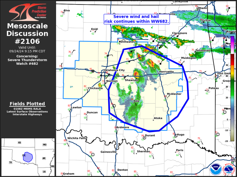
   SUMMARY...Severe wind and hail threat within WW682.

   DISCUSSION...Supercell activity continues across central Oklahoma
   along and north of a warm frontal boundary across central Oklahoma.
   Hail up to baseball size was reported earlier near the Oklahoma City
   metro. This cell has since weakened and moved southward. Additional
   supercell development is ongoing across the I-40 corridor east of
   Oklahoma City. Strong deep layer shear around 40-45 kts and MLCAPE
   around 500-1000 J/kg remains in place across central Oklahoma. This
   environment will continue to support supercells with potential for
   large hail and damaging wind to continue across this region,
   spreading southward with time through the evening.

   ..Thornton.. 09/25/2024

   ...Please see www.spc.noaa.gov for graphic product...

   ATTN...WFO...TSA...OUN...

   LAT...LON   34349695 34549734 35069738 35539715 35839703 35939699
               35999697 36079645 35609533 35269520 34869518 34479549
               34279579 34159598 34129626 34349695
|
|
Top/All Mesoscale Discussions/Forecast Products/Home
|
|


