|
| Mesoscale Discussion 2099 |
|
< Previous MD Next MD >
|
|
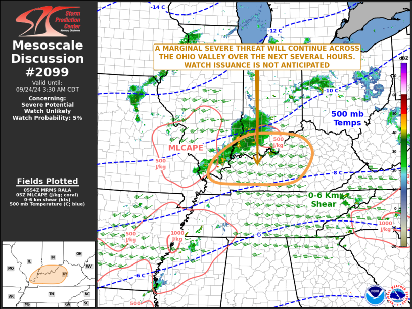
   Mesoscale Discussion 2099
   NWS Storm Prediction Center Norman OK
   1256 AM CDT Tue Sep 24 2024

   Areas affected...Kentucky...Far Southeast Illinois...Far Southern
   Indiana

   Concerning...Severe potential...Watch unlikely

   Valid 240556Z - 240830Z

   Probability of Watch Issuance...5 percent

   SUMMARY...An isolated severe threat will continue across the Ohio
   Valley over the next several hours. A severe wind gust, or a brief
   tornado will be possible. The severe threat is expected to remain
   marginal, and watch issuance appears unlikely.

   DISCUSSION...The latest water vapor imagery shows a mid-level
   shortwave trough moving into the Ozarks. A distinct vorticity max is
   evident on mosaic radar as an MCV in far southeast Missouri.
   Thunderstorms are ongoing from near the MCV extending northeastward
   into southern Illinois and southern Indiana, near a maximum in warm
   air advection. Surface dewpoints in the lower Ohio Valley are in the
   upper 60s F, and the RAP has MLCAPE up to 750 J/kg in the vicinity
   of Evansville, Indiana. The WSR-88D VWP at Louisville has 0-6 km
   shear around 45 knots, with 0-3 km storm-relative helicity around
   175 m2/s2. Directional shear is confined mostly to the lowest 1
   kilometer. This wind profile should be enough for transient
   supercell structure. Any tornado that forms would likely be brief.
   An isolated severe gust will also be possible, especially if any of
   the cells can obtain a bowing structure.

   ..Broyles/Smith.. 09/24/2024

   ...Please see www.spc.noaa.gov for graphic product...

   ATTN...WFO...ILN...LMK...IND...PAH...

   LAT...LON   38588746 37968858 37498899 37138902 36918858 36898743
               36918552 37288477 38038439 38578496 38708635 38588746
|
|
Top/All Mesoscale Discussions/Forecast Products/Home
|
|


 @NWSSPC