|
| Mesoscale Discussion 2098 |
|
< Previous MD Next MD >
|
|
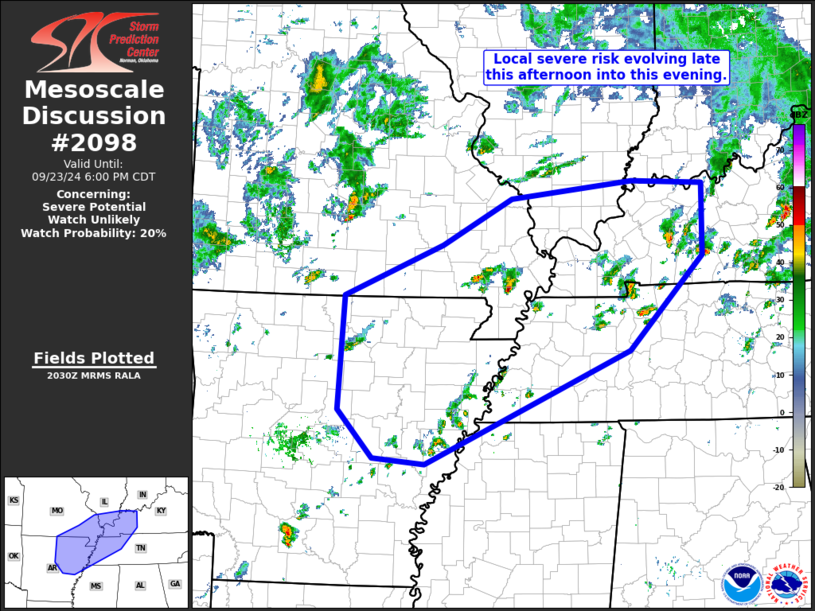
   Mesoscale Discussion 2098
   NWS Storm Prediction Center Norman OK
   0332 PM CDT Mon Sep 23 2024

   Areas affected...southeastern Missouri and northeastern Arkansas
   into the Mid Mississippi/Lower Ohio/Tennessee Valleys

   Concerning...Severe potential...Watch unlikely

   Valid 232032Z - 232300Z

   Probability of Watch Issuance...20 percent

   SUMMARY...Gradually increasing convection will pose some risk for
   gusty winds and hail, possibly reaching severe levels locally.  A
   tornado also cannot be ruled out, though overall limited/marginal
   nature of the risk expected at this time may preclude the need for
   WW consideration.

   DISCUSSION...Latest visible satellite imagery shows some thinning of
   the high clouds across southeastern Missouri and into Arkansas, near
   and ahead of the surface cold front.  Resulting, filtered heating
   has allowed 1000 to 1500 J/kg mixed-layer CAPE to evolve near and
   ahead of the boundary.  This is supporting a gradual increase in
   convective coverage across the Mid Mississippi/Lower Ohio/Tennessee
   Valleys -- and westward into the Ozarks just to the cool side of the
   front.  This increase includes a small/weakly rotating storm moving
   eastward across New Madrid County Missouri at this time.

   Low-level flow remains generally veered across the warm sector,
   limiting shear in the lowest 1km AGL.  Still, 30 to 40 kt
   west-southwesterlies at mid levels will continue to provide shear
   sufficient to support organized updrafts.  Ascent crossing
   Missouri/Arkansas at this time -- associated with a mid-level  vort
   max -- suggests some further increase in convective
   coverage/intensity over the next couple of hours.  While we will
   continue to monitor evolution, present indications remain that WW
   issuance should remain unnecessary.

   ..Goss/Guyer.. 09/23/2024

   ...Please see www.spc.noaa.gov for graphic product...

   ATTN...WFO...LMK...OHX...PAH...MEG...LSX...LZK...SGF...

   LAT...LON   36509225 37129079 37688976 37898795 37858688 36998690
               35858800 34489103 34549181 35129232 36509225
|
|
Top/All Mesoscale Discussions/Forecast Products/Home
|
|


 @NWSSPC