|
| Mesoscale Discussion 2092 |
|
< Previous MD Next MD >
|
|
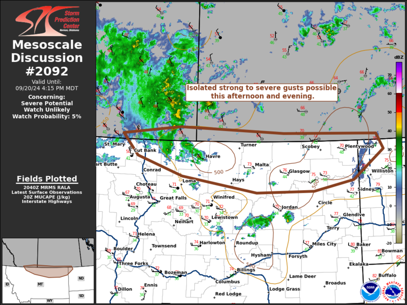
   Mesoscale Discussion 2092
   NWS Storm Prediction Center Norman OK
   0342 PM CDT Fri Sep 20 2024

   Areas affected...portions of northern Montana and North Dakota

   Concerning...Severe potential...Watch unlikely

   Valid 202042Z - 202215Z

   Probability of Watch Issuance...5 percent

   SUMMARY...Isolated strong to severe gusts are possible with
   convection near an upper low this afternoon/evening. Storm coverage
   and the lack of broader organization should keep the threat limited.

   DISCUSSION...As of 2040 UTC, regional observations showed low-topped
   showers and thunderstorms ongoing beneath an upper low over parts of
   northern MT. Cold temperatures aloft (H5 temps ~ -20C) with the
   upper low are supporting steep low and mid-level lapse rates.
   Despite poor surface moisture, (dewpoints in the 30s and 40s F) weak
   buoyancy (~500 J/Kg MUCAPE) should be sufficient to support isolated
   convection this afternoon and into the early evening hours. The
   steep lapse rates, and momentum transfer from strong flow aloft will
   support a risk for strong to severe damaging wind gusts with any
   storms able to persist. Storm coverage may gradually expand eastward
   with the upper low as it spreads into northwestern ND. Moisture
   there is slightly deeper, but buoyancy remains weak. A few strong to
   severe gusts are possible through the remainder of the afternoon and
   into the early part of this evening. Given the lack of deeper
   surface moisture and instability, a WW appears unlikely.

   ..Lyons/Guyer.. 09/20/2024

   ...Please see www.spc.noaa.gov for graphic product...

   ATTN...WFO...BIS...GGW...TFX...

   LAT...LON   48611213 49141268 49341059 49200676 49140335 48760310
               48030422 47780567 47750777 48131048 48611213
|
|
Top/All Mesoscale Discussions/Forecast Products/Home
|
|


 @NWSSPC