|
| Mesoscale Discussion 2093 |
|
< Previous MD Next MD >
|
|
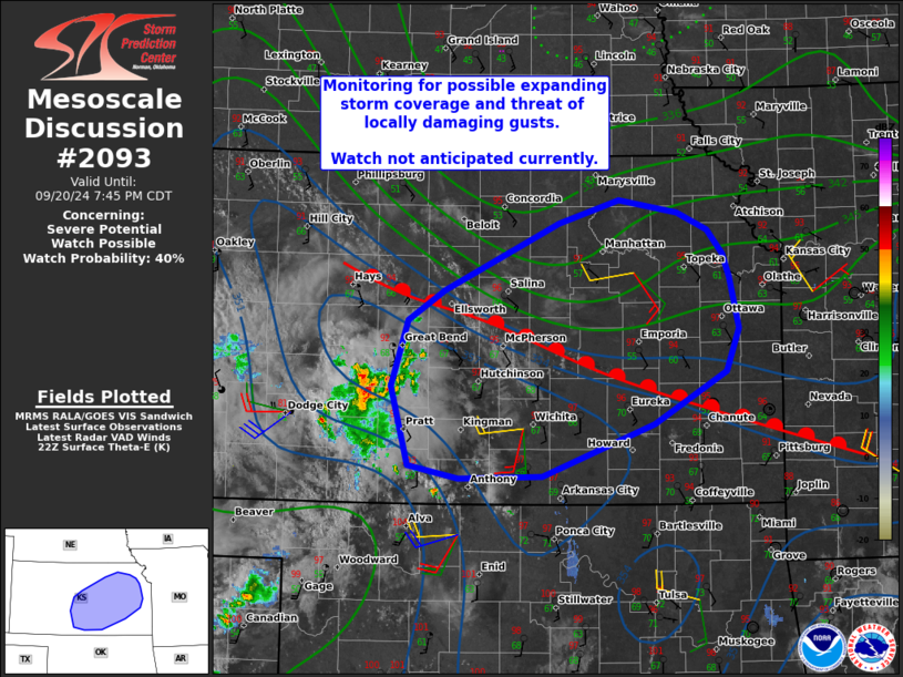
   Mesoscale Discussion 2093
   NWS Storm Prediction Center Norman OK
   0520 PM CDT Fri Sep 20 2024

   Areas affected...from south-central into northeast Kansas...and
   small parts of northwest Missouri and far southeast Nebraska

   Concerning...Severe potential...Watch possible

   Valid 202220Z - 210045Z

   Probability of Watch Issuance...40 percent

   SUMMARY...Storms over south-central Kansas may persist into the
   evening in some form and affects locations such as Wichita, Topeka
   and eventually Kansas City. Strong wind gusts appear to be the
   primary concern.

   DISCUSSION...High-based storms have moved from the Panhandles into
   south-central KS, with some strengthening noted as better moisture
   is encountered. These storms are on the nose of a hot/low-level
   lapse rates plume, and close to a warm front draped northwest to
   southeast across KS.

   Visible imagery shows other areas of towering CU just east of the
   ongoing cluster as well, near the KS/OK border, with additional CU
   fields into north-central KS in the warm advection zone.

   As the low-level jet increases this evening, the warm front is
   forecast to shift northward across KS and western MO. This will
   result in destabilization across areas that are currently stable,
   and, provide continued support for ascent via warm advection and
   with outflow boundary interactions. Given the size of the ongoing
   area of convection, trends will need to be monitored for further
   strengthening or expansion of wind threat through the evening.

   ..Jewell/Hart.. 09/20/2024

   ...Please see www.spc.noaa.gov for graphic product...

   ATTN...WFO...EAX...TOP...ICT...DDC...

   LAT...LON   38839829 39429704 39619638 39509575 39369541 39149525
               38959518 38519507 38139522 37699601 37239723 37229814
               37339869 38009887 38579869 38839829
|
|
Top/All Mesoscale Discussions/Forecast Products/Home
|
|


 @NWSSPC