|
| Mesoscale Discussion 2091 |
|
< Previous MD Next MD >
|
|
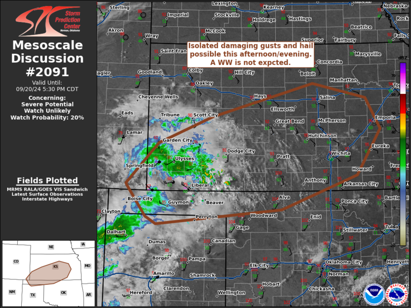
   Mesoscale Discussion 2091
   NWS Storm Prediction Center Norman OK
   0325 PM CDT Fri Sep 20 2024

   Areas affected...Portions of Oklahoma...Texas...Colorado and Kansas

   Concerning...Severe potential...Watch unlikely

   Valid 202025Z - 202230Z

   Probability of Watch Issuance...20 percent

   SUMMARY...Isolated thunderstorms may increase in coverage and
   intensity this afternoon and evening. Damaging winds and marginally
   severe hail are possible with the stronger storms.

   DISCUSSION...As of 2015 UTC, regional radar imagery showed
   high-based showers and thunderstorms ongoing over parts of southwest
   KS and the OK/TX Panhandles. Likely associated with ascent from a
   weak shortwave trough and front, these storms have persisted in a
   drier and weakly buoyant air mass through the early afternoon.
   However, convection should gradually expand northeastward toward a
   more moist and buoyant air mass (MLCAPE around 1000-1500 J/kg)
   through the remainder of the afternoon and into this evening.
   Continued heating and weak ascent will also support additional
   destabilization and storm development.

   Area VADs are supportive of some storm organization with 30-35 kt of
   deep-layer shear. A few stronger/more persistent mutlicells or even
   marginal supercell structures are possible. Damaging winds appear to
   be the most likely threat given fairly steep low-level lapse rates
   and recent reported gusts to 44 kt at KHQG. Increasing buoyancy with
   eastward extent, and some potential for supercell structures may
   also support a risk for marginally severe hail with the deeper
   storms.

   While storm coverage has so far remained isolated, additional storm
   development is expected through the afternoon/evening. Still, the
   limited overlap with buoyancy/deep-layer shear and lack of broader
   forcing for ascent should keep storm organization and coverage
   fairly limited. A WW appears unlikely at this time.

   ..Lyons/Guyer.. 09/20/2024

   ...Please see www.spc.noaa.gov for graphic product...

   ATTN...WFO...TOP...ICT...OUN...DDC...AMA...PUB...

   LAT...LON   37080254 37130256 37960175 38520036 39209777 38889640
               38259602 37309664 36619858 36300178 36450206 37080254
|
|
Top/All Mesoscale Discussions/Forecast Products/Home
|
|


 @NWSSPC