Mesoscale Discussion 2086
NWS Storm Prediction Center Norman OK
0126 PM CDT Thu Sep 19 2024
Areas affected...parts of east central and southeastern
Minnesota...adjacent northern Iowa and west central Wisconsin
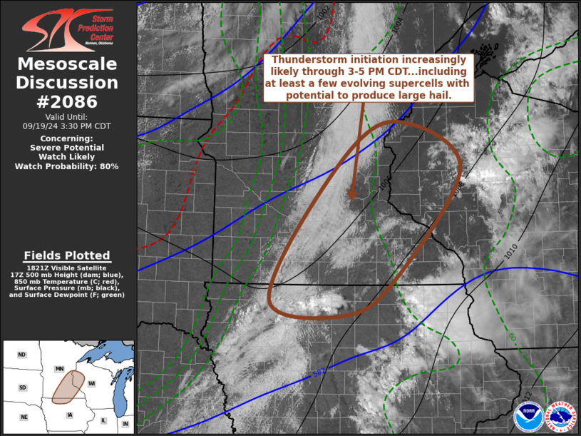
Concerning...Severe potential...Watch likely
Valid 191826Z - 192030Z
Probability of Watch Issuance...80 percent
SUMMARY...Strong thunderstorm development appears increasingly
likely through 3-5 PM CDT, near/northwest of the Greater Minneapolis
area into areas southwest of Mankato. This probably will include
the evolution of at least widely scattered supercells posing a risk
for severe hail, with largest hailstones perhaps exceeding 2 inches
in diameter.
DISCUSSION...To the southeast of an occluded lower/mid-tropospheric
cyclone, now beginning to redevelop eastward across southern
Manitoba, moderately strong destabilization is ongoing. This is
generally focused ahead of a residual wind shift, within a plume of
higher low-level moisture content which is being maintained beneath
a tongue of cool mid-level air. CAPE (up to 1500-2000 J/kg) appears
maximized within a rather narrow corridor beneath steep mid-level
lapse rates which roughly coincide with 500 mb temperatures around
-13 to -14 C. This is forecast to continue slowly shifting across
the central through eastern Minnesota vicinity through mid to late
afternoon.
A relative warm layer around or just below the 700 mb level is
tending to suppress boundary-layer based thunderstorm initiation
along the potential instability axis. However, model output is
suggestive that forcing for ascent in the left exit region of an
approaching jet streak, near the southern periphery of the cyclonic
mid/upper flow, will contribute to thunderstorm development across
southern Minnesota and adjacent northern Iowa by 20-22Z.
In the presence of at least strong deep-layer shear, it appears that
this will probably include widely scattered to scattered supercells,
initially generally west of the Minneapolis through Mankato
vicinities. These probably will pose a risk for severe hail, with
largest stones perhaps exceeding 2 inches in diameter.
..Kerr/Gleason.. 09/19/2024
...Please see www.spc.noaa.gov for graphic product...
ATTN...WFO...DLH...ARX...MPX...DMX...FSD...
LAT...LON 44949418 45939279 45289127 43599265 43039368 43259525
44949418
|


 @NWSSPC