|
| Mesoscale Discussion 2087 |
|
< Previous MD Next MD >
|

|
   Mesoscale Discussion 2087
   NWS Storm Prediction Center Norman OK
   0317 PM CDT Thu Sep 19 2024

   Areas affected...North-central Oklahoma into eastern Kansas

   Concerning...Severe potential...Watch possible

   Valid 192017Z - 192215Z

   Probability of Watch Issuance...60 percent

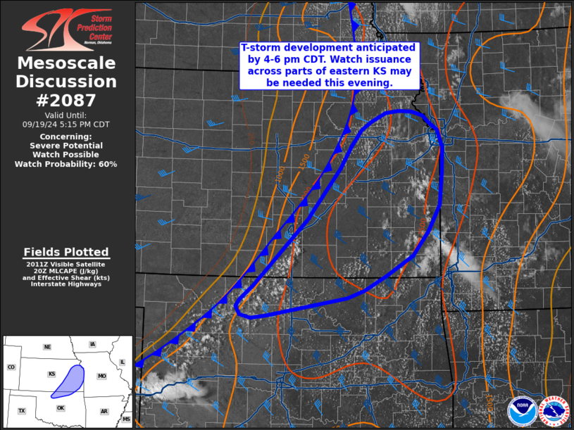
   SUMMARY...Thunderstorm development is anticipated by around 4-6 PM
   CDT across northern Oklahoma into southern/southeast Kansas. This
   activity may pose a severe hail/wind threat as it spreads into
   eastern Kansas this evening. Watch issuance may be needed later this
   afternoon/evening to address this concern.

   DISCUSSION...GOES visible imagery over the past 30 minutes has shown
   a steady uptick in cumulus development along a diffuse surface
   trough/cold front from southern KS into the eastern TX Panhandle.
   The 18 UTC sounding from TOP shows a stout cap remains in place
   across east/northeast KS, but hot temperatures across OK/southern KS
   in the upper 90s to low 100s are actively mixing out lingering
   inhibition (as evidenced by the recent deep convection along I-40 in
   western OK). This trend appears to be faster than depicted by recent
   CAM solutions, suggesting that robust initiation may occur in the
   coming hours across southern KS.

   As storms develop, they will mature in an environment characterized
   by MLCAPE values between 1500-2500 J/kg and 30-40 knots of effective
   bulk shear (based on the recent TOP sounding and latest mesosnalysis
   estimates). Deep-layer shear vectors largely orthogonal to the front
   should favor discrete cells initially with a large hail threat (most
   likely hail size between 1.0 to 1.75 inches), but increasing storm
   coverage through early evening should promote clustering with an
   increasing potential for severe winds (50-70 mph) as activity
   spreads into eastern KS. While timing remains somewhat uncertain,
   watch issuance may be needed late this afternoon/early evening
   across this region.

   ..Moore/Gleason.. 09/19/2024

   ...Please see www.spc.noaa.gov for graphic product...

   ATTN...WFO...SGF...EAX...TSA...TOP...ICT...OUN...

   LAT...LON   36889803 37859703 37989695 38609644 38919624 39169606
               39279587 39419560 39449536 39439512 39379492 39269480
               39169465 38909455 38549456 38059462 37689482 37319511
               37029559 36819600 36699632 36439778 36399808 36449827
               36579835 36669827 36889803
|
|
Top/All Mesoscale Discussions/Forecast Products/Home
|
|


