|
| Mesoscale Discussion 2085 |
|
< Previous MD Next MD >
|
|
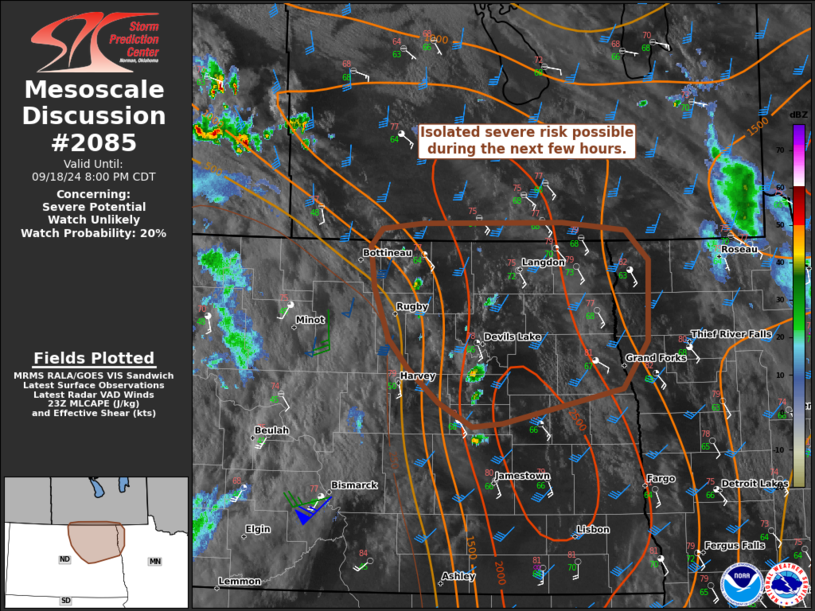
   Mesoscale Discussion 2085
   NWS Storm Prediction Center Norman OK
   0634 PM CDT Wed Sep 18 2024

   Areas affected...Portions of northeastern North Dakota into far
   northwestern Minnesota

   Concerning...Severe potential...Watch unlikely

   Valid 182334Z - 190100Z

   Probability of Watch Issuance...20 percent

   SUMMARY...Isolated severe storms capable of large hail and locally
   severe gusts cannot be ruled out during the next few hours. A watch
   is not expected.

   DISCUSSION...Attempts at convective initiation are underway across
   portions of northeastern ND, focused within a north/south-oriented
   confluence band, and near an antecedent differential heating zone.
   This activity may be aided by a lobe of midlevel ascent (evident in
   water-vapor imagery) rotating around the eastern periphery of a
   midlevel low over eastern MT. Middle/upper 60s dewpoints beneath a
   plume of steep midlevel lapse rates are contributing to moderate
   surface-based instability ahead of the developing storms.
   Additionally, regional VWP depicts a long hodograph with modest
   low-level hodograph curvature -- characterized by around 45 kt of
   effective shear. Given subtle mesoscale forcing, storm maturation is
   uncertain (especially given increasing nocturnal static stability),
   though the aforementioned parameter space will conditionally support
   a couple organized storms/supercells capable of producing large hail
   and locally severe gusts. Any severe threat here is expected to
   remain too isolated for a watch at this time.

   ..Weinman/Hart.. 09/18/2024

   ...Please see www.spc.noaa.gov for graphic product...

   ATTN...WFO...FGF...BIS...

   LAT...LON   47429858 47399898 47609941 47889981 48140007 48590026
               48940030 49090015 49159962 49169781 49089698 48839669
               48129670 47719702 47429858
|
|
Top/All Mesoscale Discussions/Forecast Products/Home
|
|


 @NWSSPC