|
| Mesoscale Discussion 2084 |
|
< Previous MD Next MD >
|
|
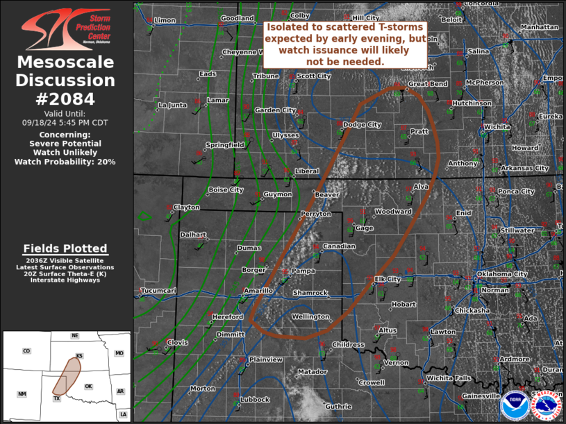
   Mesoscale Discussion 2084
   NWS Storm Prediction Center Norman OK
   0342 PM CDT Wed Sep 18 2024

   Areas affected...The eastern Texas Panhandle into northwest Oklahoma
   and southern Kansas

   Concerning...Severe potential...Watch unlikely

   Valid 182042Z - 182245Z

   Probability of Watch Issuance...20 percent

   SUMMARY...Thunderstorm development is expected by late
   afternoon/early evening across the eastern Texas Panhandle and into
   adjacent portions of northwest Oklahoma and southern Kansas.
   Thunderstorm coverage should remain sufficiently isolated to
   preclude watch issuance, but instances of severe hail/wind will be
   possible.

   DISCUSSION...Latest GOES imagery shows deepening cumulus along a
   weakly confluent surface trough across the TX Panhandle into
   southern KS. The southerly flow regime across the region has helped
   offset the influence of diurnal mixing with dewpoints remaining the
   low to mid 60s. Concurrently, temperatures are warming into the low
   to mid 90s, which is eroding inhibition and supporting MLCAPE
   upwards of around 1000 J/kg. Any further improvements to the
   thermodynamic environment will be modest through late afternoon,
   namely in the form of steepening low-level lapse rates as
   temperatures peak in the mid to upper 90s. However, nearly zonal
   30-35 knot flow aloft is supporting somewhat elongated mid-level
   hodographs with similar effective bulk shear values. This kinematic
   environment should support organized convection, including the
   potential for a supercell or two with an attendant risk for large
   hail (most likely up to 1.0-1.75 inches in diameter) and severe
   winds. Based on the aforementioned satellite trends, at least a
   couple of storms appear probable, but the fairly weak forcing for
   ascent along the surface trough and stronger inhibition downstream
   into OK and KS suggests that storm coverage and duration may be
   limited. Consequently, watch issuance is unlikely.

   ..Moore/Gleason.. 09/18/2024

   ...Please see www.spc.noaa.gov for graphic product...

   ATTN...WFO...ICT...OUN...DDC...LUB...AMA...

   LAT...LON   35020160 36810046 37789985 38129965 38369910 38379879
               38259853 38039837 37809827 37549819 37309817 37039825
               36739841 36279872 35839903 35389952 34999987 34700026
               34590067 34620121 34670144 34850167 35020160
|
|
Top/All Mesoscale Discussions/Forecast Products/Home
|
|


 @NWSSPC