|
| Mesoscale Discussion 2075 |
|
< Previous MD Next MD >
|
|
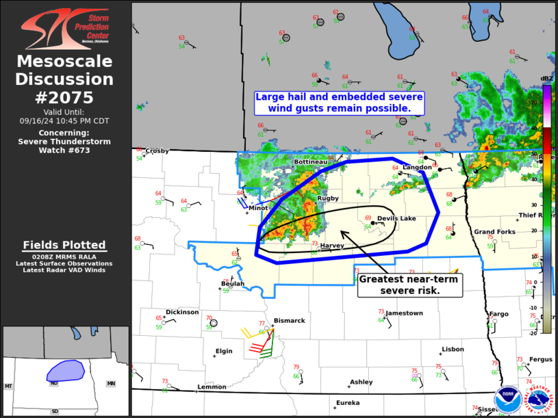
   Mesoscale Discussion 2075
   NWS Storm Prediction Center Norman OK
   0910 PM CDT Mon Sep 16 2024

   Areas affected...Portions of northern North Dakota

   Concerning...Severe Thunderstorm Watch 673...

   Valid 170210Z - 170345Z

   The severe weather threat for Severe Thunderstorm Watch 673
   continues.

   SUMMARY...Large hail and severe wind gusts remain possible across
   portions of northern North Dakota -- within Severe Thunderstorm
   Watch 673.

   DISCUSSION...Latest radar data from KMBX indicates a persistent
   cluster of thunderstorms tracking eastward along an
   east/west-oriented warm front/stationary boundary draped across
   northern North Dakota. Along the southern periphery of the cluster,
   a couple deeper/embedded rotating updrafts are evident, aided by
   warmer/moister inflow south of the boundary, and
   favorable/increasing low-level hodograph curvature (sampled by
   regional VWP data). In the near-term, large hail (generally up to
   1.75 inches) and locally severe wind gusts are the primary concerns
   with these embedded supercell structures.

   During the next few hours, this cluster of storms should maintain
   its current intensity and organization as it continues generally
   eastward along the boundary -- aided by mesoscale forcing associated
   with an embedded MCV and a plume of low-level warm advection atop
   the boundary. The primary severe risk may remain focused along the
   southern periphery of the larger thunderstorm cluster, with less
   certainty north of the boundary where low-level inhibition is
   greater.

   ..Weinman.. 09/17/2024

   ...Please see www.spc.noaa.gov for graphic product...

   ATTN...WFO...FGF...BIS...

   LAT...LON   48040104 48410063 48769990 48899941 48939852 48749794
               48249766 47849790 47759825 47600072 47690110 48040104
|
|
Top/All Mesoscale Discussions/Forecast Products/Home
|
|


 @NWSSPC