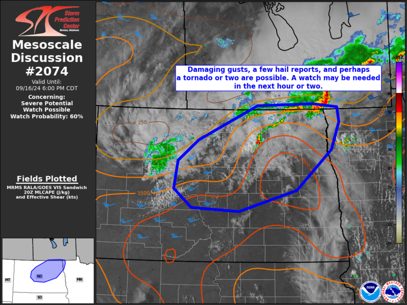
   Mesoscale Discussion 2074
   NWS Storm Prediction Center Norman OK
   0359 PM CDT Mon Sep 16 2024

   Areas affected...portions of eastern North Dakota and far
   northwestern Minnesota

   Concerning...Severe potential...Watch possible

   Valid 162059Z - 162300Z

   Probability of Watch Issuance...60 percent

   SUMMARY...Damaging gusts, a few hail reports, and perhaps a tornado
   or two are possible this afternoon and evening across portions of
   eastern North Dakota and northwestern Minnesota. A watch may be
   needed in the next hour or two.

   DISCUSSION...With a weak mid-level shortwave trough moving across
   the northern CONUS, storms are developing near a remnant boundary
   across portions of northern North Dakota this afternoon. South of
   this boundary, solar heating has resulted in air mass recovery in
   the wake of an MCS this morning. Dewpoints across central North
   Dakota are in the upper 60s and low 70s with temperatures generally
   near 80, resulting in appreciable CAPE. Additionally, some shear is
   present, with 10-15 kts 0-1 km shear from the KBIS VWP and 30-40 kts
   of effective bulk shear per mesoanalysis.

   With initial discrete convection, some severe hail is expected given
   deep CAPE profiles and modest low-level shear. Additionally, a
   tornado or two cannot be ruled out, given an increasing low-level
   jet this evening. However, the window for such a tornado threat may
   be short before convection grows upscale due to merging cold pools.
   From there, a damaging wind threat should become more dominant
   through the evening hours.

   ..Supinie/Gleason.. 09/16/2024

   ...Please see www.spc.noaa.gov for graphic product...

   ATTN...WFO...FGF...BIS...

   LAT...LON   49109754 49039681 48739677 48189700 47389805 46959977
               47030117 47400170 47960158 48380098 49089921 49109754
|


 @NWSSPC