|
| Mesoscale Discussion 2072 |
|
< Previous MD Next MD >
|

|
   Mesoscale Discussion 2072
   NWS Storm Prediction Center Norman OK
   0134 PM CDT Mon Sep 16 2024

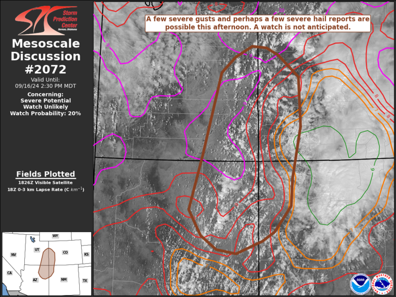
   Areas affected...the Four Corners Region

   Concerning...Severe potential...Watch unlikely

   Valid 161834Z - 162030Z

   Probability of Watch Issuance...20 percent

   SUMMARY...Some severe gusts and perhaps some severe hail are
   possible this afternoon near the Four Corners Region. A watch is not
   anticipated at this time, however trends will be monitored.

   DISCUSSION...Thunderstorms have developed near the Mogollon Rim over
   northeastern Arizona this afternoon. These storms are on the
   southeastern periphery of an expansive upper-level closed low with a
   seasonably strong mid-level jet (40-50 kts of 500 mb flow). This
   results in 30-40 kts of effective bulk shear across the region.
   Additionally, strong heating has warmed temperatures into the mid
   70s to near 80 F, resulting in steep low-level lapse rates (8-9
   C/km) and 1000+ J/kg of DCAPE per mesoanalysis. The deep-layer shear
   induced by the upper-level trough is expected to result in multicell
   clusters of storms with severe gusts being the primary threat.
   However given the steep lapse rates, straight hodographs, and low
   freezing levels, some marginally severe hail may occur as well.
   Given the expected sparse coverage of both of these, a watch is not
   anticipated. With time, expect clusters to move to the northeast.
   Some residual cloud cover over the San Juan Mountains is resulting
   in lingering stable air, so this may limit the longevity of these
   storms.

   ..Supinie/Gleason.. 09/16/2024

   ...Please see www.spc.noaa.gov for graphic product...

   ATTN...WFO...ABQ...GJT...FGZ...SLC...

   LAT...LON   35171077 35791115 37151074 39171018 39540976 39810923
               39770877 39590840 39060778 37830774 36580801 35890806
               35260856 35030893 34720972 34831031 35171077
|
|
Top/All Mesoscale Discussions/Forecast Products/Home
|
|


