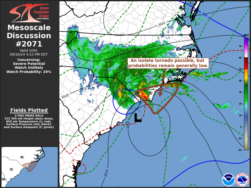
   Mesoscale Discussion 2071
   NWS Storm Prediction Center Norman OK
   1211 PM CDT Mon Sep 16 2024

   Areas affected...coastal southern North Carolina

   Concerning...Severe potential...Watch unlikely

   Valid 161711Z - 162015Z

   Probability of Watch Issuance...20 percent

   SUMMARY...While the risk for a brief tornado may not be negligible
   across the southern North Carolina coastal plain, this potential
   still appears low.  It is possible that it may not increase
   appreciably either, but trends are being closely monitored.

   DISCUSSION...The surface cyclone center appears to be slowly
   approaching coastal areas to the west/west-northwest of Myrtle Beach
   SC.  Forcing for ascent aided by strongest low-level convergence and
   warm advection has been focused to its north, spreading inland
   near/south through southwest of Wilmington.  This has been
   contributing to the most vigorous thunderstorm development,
   supported by inflow of tropically moist boundary-layer air within a
   narrow offshore plume wrapping around the periphery of the cyclone.

   Low-level hodographs across coastal southern North Carolina remain
   sizable and clockwise curved, supporting at least a couple of
   occasionally intensifying supercell structures over the past hour or
   two.  However, inland of immediate coastal areas, the convection and
   embedded mesocyclones probably have been based above at least a
   residual shallow stable surface-based layer, based on surface
   observations and Rapid Refresh forecast soundings.

   Beneath a subsident mid-level dry slot wrapping around the southern
   periphery of the cyclone, model output suggests that low-level
   warming within a small inland advecting wedge may contribute to
   modest boundary-layer destabilization through mid to late afternoon,
   as the cyclone slowly begins to migrate inland.  However, with
   strongest flow around 850 mb forecast to shift into the Carolina
   Piedmont, model forecast soundings generally indicate that this may
   coincide with shrinking and less clockwise curved low-level
   hodographs.  Coupled with potentially increasing mid-level
   inhibition, the risk for convection capable of producing tornadoes
   remains uncertain.

   ..Kerr/Gleason.. 09/16/2024

   ...Please see www.spc.noaa.gov for graphic product...

   ATTN...WFO...MHX...ILM...

   LAT...LON   33957840 34277866 34587686 34207681 33397770 33657804
               33957840
|


 @NWSSPC