|
| Mesoscale Discussion 2070 |
|
< Previous MD Next MD >
|
|
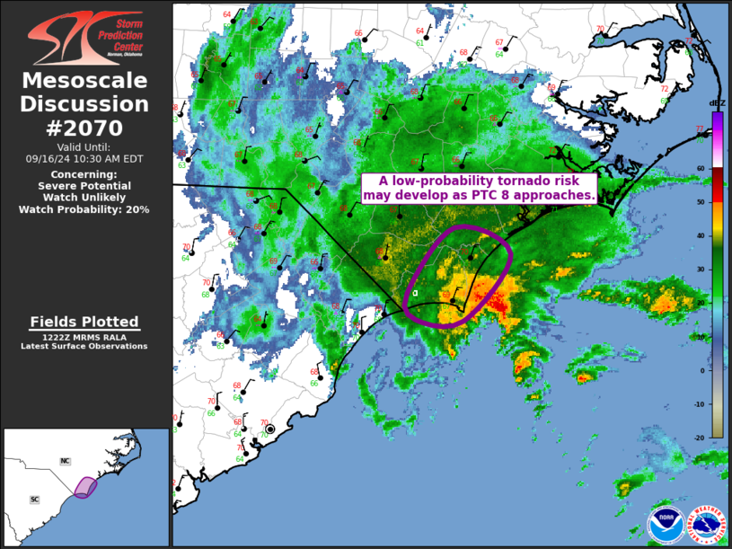
   Mesoscale Discussion 2070
   NWS Storm Prediction Center Norman OK
   0724 AM CDT Mon Sep 16 2024

   Areas affected...Far Southern NC Coast

   Concerning...Severe potential...Watch unlikely

   Valid 161224Z - 161430Z

   Probability of Watch Issuance...20 percent

   SUMMARY...A low-probability tornado risk could develop across far
   southern coastal North Carolina as Potential Tropical Cyclone 8
   approaches the region.

   DISCUSSION...The area of low pressure (dubbed Potential Tropical
   Cyclone 8 by NHC) off the southern NC/northern SC continues to
   slowly move northwestward towards the coast. Abundant precipitation
   to the northwest of this low has been ongoing across the
   southern/central NC coast for much of the night, limiting
   destabilization. Even so, a more buoyant airmass likely exists just
   offshore, as evidenced by the recent lightning within the deep
   convection about 30 miles south-southeast of ILM. Gradual
   northwestward progression of the low could bring this more buoyant
   air onshore over the immediate southern NC Coast. Strong low-level
   wind fields exist around this low, as sampled by the LTX VAD, and a
   few areas of transient low-level rotation have been noted from the
   LTX radar as well.

   General expectation is for most of the deeper convection to remain
   offshore for the next few hours, with the exception of the
   previously mentioned immediate coast of southern NC. Here, there is
   a chance of more persistent deep convection which could support a
   low-probability tornado risk.

   ..Mosier/Edwards.. 09/16/2024

   ...Please see www.spc.noaa.gov for graphic product...

   ATTN...WFO...ILM...

   LAT...LON   33777841 33987849 34507804 34307751 33767795 33777841
|
|
Top/All Mesoscale Discussions/Forecast Products/Home
|
|


 @NWSSPC