|
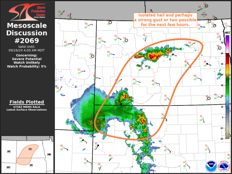
| Mesoscale Discussion 2069 |
|
< Previous MD Next MD >
|
|
   Mesoscale Discussion 2069
   NWS Storm Prediction Center Norman OK
   0300 AM CDT Mon Sep 16 2024

   Areas affected...Northeast SD...Southern/Central ND

   Concerning...Severe potential...Watch unlikely

   Valid 160800Z - 161000Z

   Probability of Watch Issuance...5 percent

   SUMMARY...Threat for isolated hail and/or strong gusts will continue
   from northeast South Dakota into central North Dakota for the next
   few hours. Limited coverage and magnitude will preclude the need for
   a watch.

   DISCUSSION...Elevated thunderstorms are ongoing across northwest SD
   and adjacent far southwest ND, supported by warm-air advection
   within the localized warm conveyor associated with the mesoscale
   convective vortex currently over far northwest SD. These
   thunderstorms are forecast to continue north-northeastward over the
   next few hours while gradually weakening in response to decreasing
   warm-air advection. Even so, the environment downstream across
   south-central ND appears favorable for evaporatively enhanced
   downbursts and the potential for some strong gusts.

   Farther north, a west-to-east oriented band of thunderstorms
   recently developed in response to persistent warm-air advection near
   the terminus of the low-level jet that extends across the Plains.
   Recent radar imagery has shown that the previously more cellular
   storms may be transitioning into a more clustered mode, with some
   more easterly motion noted as well. Low-level stability will persist
   downstream, but enough elevated buoyancy is expected to allow for
   thunderstorm persistence. Consequently, the developing linear
   cluster will likely continue east-southeastward with an attendant
   risk for isolated hail. A strong gust or two may be able to reach
   the surface as well.

   ..Mosier/Edwards.. 09/16/2024

   ...Please see www.spc.noaa.gov for graphic product...

   ATTN...WFO...FGF...ABR...BIS...UNR...

   LAT...LON   45300399 46450319 47720207 48300017 48079831 46729969
               44880093 44820309 45300399
|
|
Top/All Mesoscale Discussions/Forecast Products/Home
|
|


 @NWSSPC