|
| Mesoscale Discussion 2068 |
|
< Previous MD Next MD >
|
|
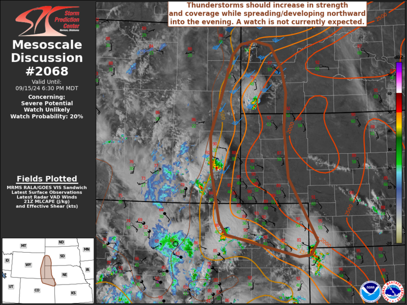
   Mesoscale Discussion 2068
   NWS Storm Prediction Center Norman OK
   0500 PM CDT Sun Sep 15 2024

   Areas affected...portions of northeastern CO...western NE...eastern
   WY...and southwestern SD

   Concerning...Severe potential...Watch unlikely

   Valid 152200Z - 160030Z

   Probability of Watch Issuance...20 percent

   SUMMARY...Thunderstorms should increase in strength and coverage
   while spreading/developing northward across the central/northern
   High Plains into this evening. The strongest storms will be capable
   of producing severe wind gusts and isolated large hail.

   DISCUSSION...Latest water-vapor imagery depicts an embedded midlevel
   impulse tracking northeastward across portions of northern CO this
   afternoon, and regional VWP shows around 20-30-kt midlevel flow
   accompanying this feature. Associated large-scale ascent will
   promote an increase in thunderstorm development along the
   central/northern High Plains -- generally focused on the moist side
   of a lee trough. Steep deep-layer lapse rates (sampled by recent DEN
   ACARS soundings) amid lower/middle 50s dewpoints are contributing to
   sufficient buoyancy for gradual updraft intensification.
   Additionally, the enhanced midlevel southwesterly flow atop
   low-level southeasterlies is favoring 20-30 kt of effective shear --
   sufficient for loosely organized clusters and brief supercell
   structures. As as result, severe winds gusts and isolated large hail
   will be possible with the strongest storms as they spread/develop
   northward into this evening. Given the increasing large-scale ascent
   and favorable environment for strong convective outflow generation,
   there may be a tendency for localized upscale growth with time,
   which would further increase the severe-wind risk.

   Current expectation is for the marginal deep-layer shear to limit
   overall convective organization and intensity, and a watch is not
   currently expected. However, convective trends will be monitored
   into this evening.

   ..Weinman/Guyer.. 09/15/2024

   ...Please see www.spc.noaa.gov for graphic product...

   ATTN...WFO...LBF...UNR...GLD...BOU...CYS...

   LAT...LON   39840198 39800232 40300445 40580467 41730491 42500495
               44300429 44540405 44610364 44500315 43990281 43460267
               42640275 41560262 40150177 39840198
|
|
Top/All Mesoscale Discussions/Forecast Products/Home
|
|


 @NWSSPC