|
| Mesoscale Discussion 2067 |
|
< Previous MD Next MD >
|
|
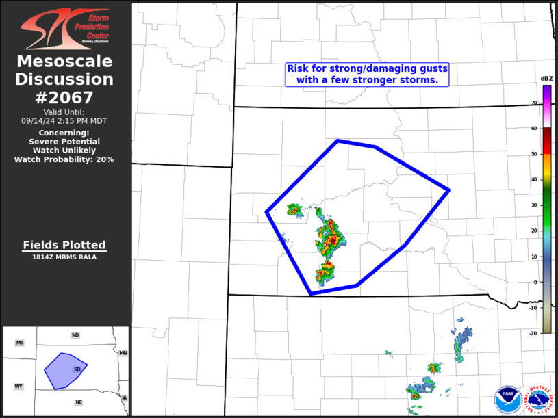
   Mesoscale Discussion 2067
   NWS Storm Prediction Center Norman OK
   0116 PM CDT Sat Sep 14 2024

   Areas affected...portions of western and central South Dakota

   Concerning...Severe potential...Watch unlikely

   Valid 141816Z - 142015Z

   Probability of Watch Issuance...20 percent

   SUMMARY...Isolated thunderstorms -- the strongest of which may
   produce strong/damaging wind gusts and possibly severe-caliber hail
   -- are expected from parts of western and central South Dakota.  The
   very isolated nature of the risk anticipated at this time should
   preclude the need for WW issuance.

   DISCUSSION...Latest radar loop shows isolated, vigorous storms east
   of the Black Hills area, with the strongest cells moving
   northeastward across the Haakon/Jackson County area at this time.
   The convection is ongoing within an environment featuring modestly
   increasing/veering flow with height, providing shear sufficient for
   at least multicell organization.  Though CAPE will remain limited
   due to the dry boundary layer (around 1000 J/kg mixed-layer CAPE
   will prevail across the area), a deep sub-cloud layer has evolved in
   conjunction with diurnal heating.  As such, sub-cloud evaporation --
   and thus potential for acceleration of the downdrafts -- suggests
   that a few stronger/potentially severe gusts will be possible.
   However, with storms expected to remain isolated, severe-weather
   coverage is expected to remain insufficient to require WW
   consideration.

   ..Goss/Gleason.. 09/14/2024

   ...Please see www.spc.noaa.gov for graphic product...

   ATTN...WFO...ABR...UNR...

   LAT...LON   45440172 44300327 43030229 43170131 43800026 44659929
               45330089 45440172
|
|
Top/All Mesoscale Discussions/Forecast Products/Home
|
|


 @NWSSPC