|
| Mesoscale Discussion 2062 |
|
< Previous MD Next MD >
|
|
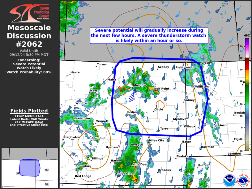
   Mesoscale Discussion 2062
   NWS Storm Prediction Center Norman OK
   0458 PM CDT Thu Sep 12 2024

   Areas affected...Portions of northeastern Montana and western North
   Dakota

   Concerning...Severe potential...Watch likely

   Valid 122158Z - 122330Z

   Probability of Watch Issuance...80 percent

   SUMMARY...The potential for severe gusts and instances of large hail
   will gradually increase over the next few hours across northeastern
   Montana and western North Dakota. A severe thunderstorm watch is
   likely within an hour or so.

   DISCUSSION...Latest water-vapor imagery and regional VWP data
   indicate the left-exit region of a midlevel jet streak overspreading
   portions of north-central WY -- ahead of a deep midlevel low
   centered over southwestern MT. Over the next few hours, related
   large-scale ascent will overspread northeastern MT, promoting a
   gradual increase in convective development. Around 50-60 kt of
   midlevel south-southwesterly flow is contributing to a long/mostly
   straight hodograph -- characterized by 45-55 kt of effective shear.
   Despite somewhat cool post-frontal boundary-layer conditions, and
   lingering inhibition at the base of a robust EML, the strong
   deep-layer shear and steep midlevel lapse rates will still favor
   organized clusters and embedded supercells. These storms will be
   capable of producing severe gusts and instances of large hail.
   Significant severe gusts (75-85 mph) will be possible, especially
   with any congealing cold pools that evolve.

   A severe thunderstorm watch is likely for portions of the area
   within an hour or so.

   ..Weinman/Smith.. 09/12/2024

   ...Please see www.spc.noaa.gov for graphic product...

   ATTN...WFO...BIS...BYZ...GGW...

   LAT...LON   47170755 47760759 48830747 49030725 49150660 49080371
               48920330 47820298 46750333 46590388 46670668 46800734
               47170755
|
|
Top/All Mesoscale Discussions/Forecast Products/Home
|
|


 @NWSSPC