|
| Mesoscale Discussion 2061 |
|
< Previous MD Next MD >
|

|
   Mesoscale Discussion 2061
   NWS Storm Prediction Center Norman OK
   0240 PM CDT Thu Sep 12 2024

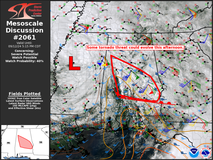
   Areas affected...Parts of central into south AL

   Concerning...Severe potential...Watch possible

   Valid 121940Z - 122215Z

   Probability of Watch Issuance...40 percent

   SUMMARY...Some tornado threat could evolve this afternoon.

   DISCUSSION...Persistent cloudiness has thus far limited
   destabilization north of a warm front draped across south AL.
   However, some modest destabilization (with MLCAPE approaching or
   exceeding 500 J/kg) will be possible from south to north this
   afternoon as the warm front moves slowly northward. One persistent
   cell is ongoing northeast of Montgomery, and additional low-topped
   supercell development will be possible along/north of the warm front
   through the afternoon.

   Stronger low-level flow/shear will gradually shift northward in
   conjunction with the warm front through the afternoon, but will
   generally remain favorable, with 0-1 km SRH generally in the 150-300
   m2/s2 range in areas where modest destabilization is possible. Some
   tornado threat could evolve with time this afternoon, contingent on
   the development of additional low-topped supercells. Observational
   trends will be monitored regarding the need for a Tornado Watch.

   ..Dean/Guyer.. 09/12/2024

   ...Please see www.spc.noaa.gov for graphic product...

   ATTN...WFO...TAE...BMX...MOB...

   LAT...LON   32018746 32638764 33078779 33918793 33548696 33218620
               32888563 32598540 32088512 31848518 31718528 31708551
               31768600 31858669 31958717 32018746
|
|
Top/All Mesoscale Discussions/Forecast Products/Home
|
|


