|
| Mesoscale Discussion 2054 |
|
< Previous MD Next MD >
|
|
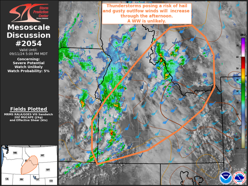
   Mesoscale Discussion 2054
   NWS Storm Prediction Center Norman OK
   0326 PM CDT Wed Sep 11 2024

   Areas affected...Portions of southern Idaho into southwestern
   Montana

   Concerning...Severe potential...Watch unlikely

   Valid 112026Z - 112300Z

   Probability of Watch Issuance...5 percent

   SUMMARY...Thunderstorms are expected to increase in coverage and
   intensity through the afternoon posing a risk of severe hail and
   wind.  The severe threat is expected to be too isolated and marginal
   to warrant a severe thunderstorm watch.

   DISCUSSION...A potent shortwave trough evident in water vapor
   imagery this afternoon is nosing into southwestern Idaho.  As a
   result of the corresponding focused ascent, thunderstorms will
   continue to increase in coverage and intensity across the area
   through the afternoon and evening hours.  Despite strong forcing for
   ascent and sufficient shear for supercells and organized storm
   modes, the moisture and instability are rather modest.
   Consequently, storms will be relatively high based, which will favor
   strong evaporative cooling and isolated severe gusts through the
   evening hours.

   Additionally, strong outflow winds from these thunderstorms will
   likely impact existing fires across the region, which may hinder
   fire suppression/containment efforts.

   ..Jirak/Guyer.. 09/11/2024

   ...Please see www.spc.noaa.gov for graphic product...

   ATTN...WFO...TFX...PIH...MSO...BOI...LKN...

   LAT...LON   43431733 44231670 45571521 46281430 46781351 46841240
               46421176 45791135 44651137 43871199 43161318 42471464
               42131610 41951702 42401729 43431733
|
|
Top/All Mesoscale Discussions/Forecast Products/Home
|
|


 @NWSSPC