|
| Mesoscale Discussion 2053 |
|
< Previous MD Next MD >
|
|
Mesoscale Discussion 2053
NWS Storm Prediction Center Norman OK
0323 PM CDT Wed Sep 11 2024
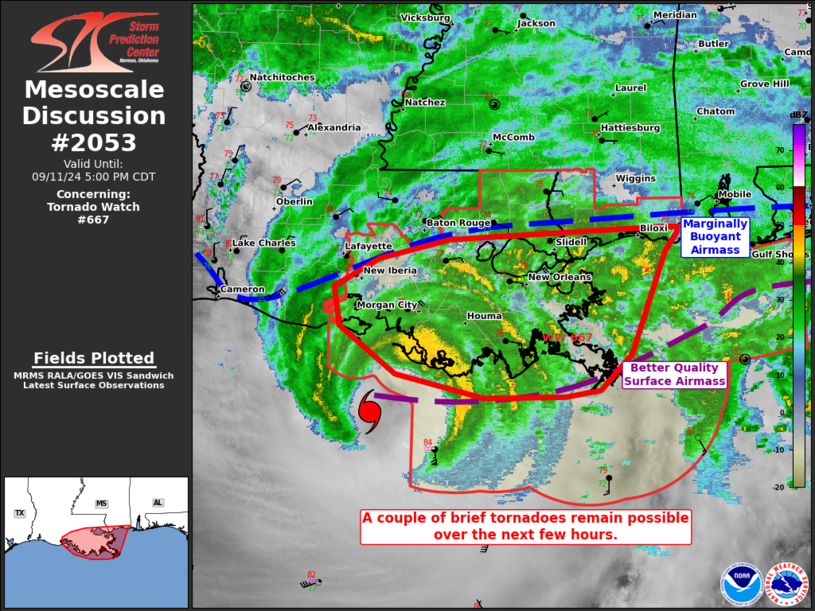
Areas affected...portions of southern and eastern Louisiana into
southern Mississippi
Concerning...Tornado Watch 667...
Valid 112023Z - 112200Z
The severe weather threat for Tornado Watch 667 continues.
SUMMARY...The severe threat continues across Tornado Watch 667. A
brief tornado or two cannot be ruled out over the next few hours.
DISCUSSION...Multiple transient supercells, embedded within the
broader rainbands associated with Hurricane Francine, have
percolated in intensity and organization over the past few hours
across southeast LA and adjacent areas offshore. However, a
widespread and persistent rain-shield has limited diurnal heating,
with surface temperatures barely exceeding the mid 70s F amid mid
70s F dewpoints. The resultant thermodynamic profiles yields scant
buoyancy inland, with MLCAPE limited to 500 J/kg (perhaps less in
spots), which is likely tempering tornado potential. Nonetheless,
HDC VAD profiler trends show hodographs increasing in size and
curvature as vertical wind fields increase in intensity with the
approach of Francine's center. As such, a couple of brief tornadoes
cannot be ruled out where any longer-lived, sustained supercell
structure can traverse a favorable overlapping buoyancy/shear
parameter space.
..Squitieri.. 09/11/2024
...Please see www.spc.noaa.gov for graphic product...
ATTN...WFO...LIX...LCH...
LAT...LON 29119144 29559204 29919209 30189163 30359087 30478862
30478846 30418846 30238859 29928872 29308895 28968928
28908966 28909051 29119144
|
|
Top/All Mesoscale Discussions/Forecast Products/Home
|
|


 @NWSSPC