|
| Mesoscale Discussion 2045 |
|
< Previous MD Next MD >
|
|
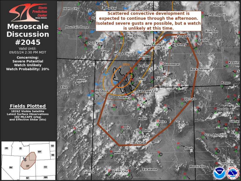
   Mesoscale Discussion 2045
   NWS Storm Prediction Center Norman OK
   0131 PM CDT Tue Sep 03 2024

   Areas affected...southwestern WY into north-central UT and extreme
   southeastern ID

   Concerning...Severe potential...Watch unlikely

   Valid 031831Z - 032030Z

   Probability of Watch Issuance...20 percent

   SUMMARY...Scattered thunderstorm development is underway across
   southwestern WY into extreme southeastern ID and north-central UT.
   This is expected to continue through the afternoon with some severe
   gusts possible with the strongest storms. The overall threat is
   expected to remain low, and a watch is unlikely at this time.

   DISCUSSION...Numerous towering updrafts have developed in the last
   hour along the higher terrain across central UT and eastern NV per
   visible satellite imagery. These maturing storms are driven by
   diurnal heating and a weakening mid-level trough propagating
   eastward through the region. Deep, well-mixed boundary layers abound
   in this environment, as characterized by short-term RAP and NAM
   forecast profiles. Steadily increasing westerly flow is anticipated
   as the mid-level trough approaches, yielding relatively
   unidirectional 0-6-km shear around 25+ kts. This should support some
   updraft organization and rotation, possibly including transient,
   high-based supercell structures. Localized severe wind gusts are
   possible with microbursts forming from stronger cores that encourage
   descent through the deep, well-mixed boundary layer. This severe
   risk should continue through peak heating, but the overall threat is
   expected to remain rather marginal, and a watch appears unlikely at
   this time.

   ..Flournoy/Squitieri/Smith.. 09/03/2024

   ...Please see www.spc.noaa.gov for graphic product...

   ATTN...WFO...RIW...GJT...SLC...PIH...

   LAT...LON   41221266 42161163 42981038 42980935 41890877 40480916
               39461034 38791144 38741273 39551381 40691337 41221266
|
|
Top/All Mesoscale Discussions/Forecast Products/Home
|
|


 @NWSSPC