|
| Mesoscale Discussion 2044 |
|
< Previous MD Next MD >
|
|
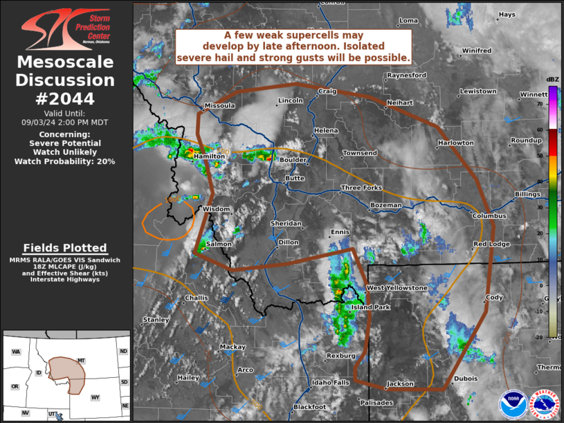
   Mesoscale Discussion 2044
   NWS Storm Prediction Center Norman OK
   0107 PM CDT Tue Sep 03 2024

   Areas affected...southwest MT and northwest WY

   Concerning...Severe potential...Watch unlikely

   Valid 031807Z - 032000Z

   Probability of Watch Issuance...20 percent

   SUMMARY...A few weak supercells may develop by late afternoon across
   parts of the northern Rockies. Isolated severe hail and strong to
   localized severe gusts will be possible.

   DISCUSSION...Convection has gradually increased into midday, but
   should increase more prominently by 19-20Z as MLCIN further wanes
   and large-scale ascent persists downstream of a smoke-filled
   mid-level low near the Bitterroot Range. To its southeast, the
   Pocatello VWP has consistently sampled the belt of stronger
   mid-level southwesterlies from 40-45 kts, with values likely in the
   30s farther north across southwest MT. With a confined mid-level
   cold core gradually shifting east, the greater potential for
   0.75-1.5 inch hail should be focused initially across southwest MT.
   With moderate surface temperature-dew point spreads near/west of the
   Absaroka Range, wind gusts should largely be sub-severe, but may
   locally reach 50-65 mph. Somewhat greater wind potential may occur
   farther east from the Lewiston-Billings-Cody corridor as convection
   spreads into a more deeply mixed environment later.

   ..Grams/Smith.. 09/03/2024

   ...Please see www.spc.noaa.gov for graphic product...

   ATTN...WFO...BYZ...RIW...TFX...PIH...MSO...

   LAT...LON   46690982 46020913 45450886 44410902 43460977 43471074
               43581127 43731127 43921111 44351102 44741107 45191132
               45001245 44921341 45121406 45851377 46281393 46581408
               46831407 47111339 47221233 47051100 46690982
|
|
Top/All Mesoscale Discussions/Forecast Products/Home
|
|


 @NWSSPC