|
| Mesoscale Discussion 2043 |
|
< Previous MD Next MD >
|
|
Mesoscale Discussion 2043
NWS Storm Prediction Center Norman OK
0356 PM CDT Mon Sep 02 2024
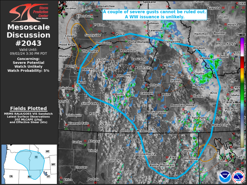
Areas affected...portions of eastern Oregon into northeast Nevada
and western into central Idaho
Concerning...Severe potential...Watch unlikely
Valid 022056Z - 022230Z
Probability of Watch Issuance...5 percent
SUMMARY...A couple of strong to severe gusts may accompany the
deeper storm cores that manage to develop. Any severe threat that
materializes should be sparse, and a WW issuance is not expected.
DISCUSSION...A pronounced 500 mb vort max is currently traversing
the CA/OR border, aiding in the ascent of marginally buoyant
boundary-layer based parcels. MRMS mosaic radar imagery shows
convective initiation underway from the lee of the Cascades toward
eastern ID. These storms are developing atop a very dry boundary
layer (evident via 50-60 F surface temperature/dewpoint spreads),
with RAP forecast soundings showing inverted-v soundings extending
up to 500 mb. As such, these storms will be high-based in nature.
Strong mid-level flow is overspreading portions of the Interior West
ahead of the approaching trough, contributing to 30+ kts of
effective bulk shear. As such, a few storms may become marginally
organized, capable producing strong to potentially severe gusts.
However, severe potential is highly dependent on how vertically deep
storm cores can become. The severe gust threat is expected to be
sparse, and a WW issuance is not anticipated.
..Squitieri/Smith.. 09/02/2024
...Please see www.spc.noaa.gov for graphic product...
ATTN...WFO...TFX...SLC...PIH...MSO...BOI...LKN...OTX...PDT...
MFR...
LAT...LON 44142133 44812118 45552062 46051987 46361816 45771419
44861296 43951263 41821330 40791411 40221486 40001533
40001577 40221636 40551693 41031717 41781741 42351781
42831848 43191920 43472024 43572053 44142133
|
|
Top/All Mesoscale Discussions/Forecast Products/Home
|
|


 @NWSSPC