|
| Mesoscale Discussion 2038 |
|
< Previous MD Next MD >
|
|
Mesoscale Discussion 2038
NWS Storm Prediction Center Norman OK
0551 PM CDT Fri Aug 30 2024
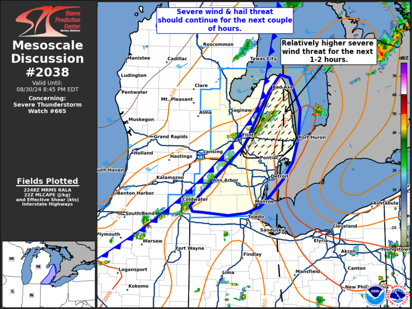
Areas affected...Southeast lower Michigan
Concerning...Severe Thunderstorm Watch 665...
Valid 302251Z - 310045Z
The severe weather threat for Severe Thunderstorm Watch 665
continues.
SUMMARY...The threat for severe wind and hail should persist for the
next 2 to 2.5 hours across southeastern Lower Michigan. The greatest
severe wind risk may reside along and north of I-65 during this
period.
DISCUSSION...Convection continues to develop along a cold front
across lower MI. Overall intensification has been somewhat gradual,
likely owing to somewhat meager large-scale ascent over the region.
However, KDTX VWP observations have shown a slight strengthening of
mid-level flow over the past 30-60 minutes with 0-6 km bulk shear
values increasing closer to 30 knots at times. Additionally, GOES
1-minute imagery shows several strong updraft pulses along the line,
indicating that the potential for organized convection persists.
Confidence in the coverage of robust convection remains limited
given the aforementioned weak forcing for ascent and recent
convective trends, but a few severe storms with an attendant
hail/severe wind risk remain possible as the cold front continues to
push east (especially along and north of I-65 where convection is
comparatively more intense based on IR and lightning trends). Latest
timing guidance suggests that this activity should exit southeastern
lower MI within the next 2-3 hours.
..Moore.. 08/30/2024
...Please see www.spc.noaa.gov for graphic product...
ATTN...WFO...DTX...IWX...GRR...
LAT...LON 41898480 42888362 43798304 44058279 44018259 43488235
42998239 42628252 42338274 42068302 41888326 41788357
41738396 41798454 41808474 41898480
|
|
Top/All Mesoscale Discussions/Forecast Products/Home
|
|


 @NWSSPC