|
| Mesoscale Discussion 2039 |
|
< Previous MD Next MD >
|
|
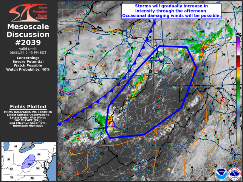
   Mesoscale Discussion 2039
   NWS Storm Prediction Center Norman OK
   1139 AM CDT Sat Aug 31 2024

   Areas affected...Southeast Ohio...southwest
   Pennsylvania...northern/central West Virginia...far western Maryland

   Concerning...Severe potential...Watch possible

   Valid 311639Z - 311845Z

   Probability of Watch Issuance...40 percent

   SUMMARY...Development of scattered thunderstorms is possible ahead
   of the cold front. Wind damage will be the main hazard this
   afternoon. A watch is possible depending on trends in convective
   intensity.

   DISCUSSION...Ahead of a cold front, some areas have already heated
   up into the mid/upper 80s F. Morning observed soundings from across
   the upper Ohio Valley vicinity show very weak mid-level lapse rates.
   This should act to limit overall buoyancy despite the warming
   temperatures and moderately moist airmass (mid/upper 60s F
   dewpoints). Further, developing thunderstorms will take time to
   intensify in such an environment. With very broad, low amplitude
   troughing across the lower Great Lakes/Northeast, deep-layer shear
   will also be relatively modest as well. The primary risk with storms
   this afternoon will be damaging winds as low-level lapse rates
   should be steep by the afternoon. This will especially be true
   if/where clustering of cold pools can occur.

   ..Wendt/Bunting.. 08/31/2024

   ...Please see www.spc.noaa.gov for graphic product...

   ATTN...WFO...CTP...LWX...PBZ...RLX...

   LAT...LON   38328244 39068234 39558184 40248119 40978027 40947915
               40277875 39027940 38188090 38068225 38328244
|
|
Top/All Mesoscale Discussions/Forecast Products/Home
|
|


 @NWSSPC