|
| Mesoscale Discussion 2033 |
|
< Previous MD Next MD >
|
|
Mesoscale Discussion 2033
NWS Storm Prediction Center Norman OK
0440 PM CDT Thu Aug 29 2024
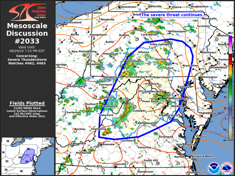
Areas affected...portions of the Mid Atlantic
Concerning...Severe Thunderstorm Watch 662...663...
Valid 292140Z - 292315Z
The severe weather threat for Severe Thunderstorm Watch 662, 663
continues.
SUMMARY...The severe threat continues across WW663. Clusters of
strong to severe storms should continue into this evening. Damaging
wind gusts and occasional hail are possible.
DISCUSSION...As of 2130 UTC, several clusters of strong to severe
storms were ongoing across WW633. Over the past several hours, these
clusters have produced occasional damaging wind gusts and isolated
severe hail. The environment across the watch area and much of the
Mid Atlantic remains unstable and modestly sheared with 2000 J/kg of
MLCAPE from SPC mesoanalysis and 20-25 kt of effective shear via
area VADs. Convective coverage may increase slightly over the next
coupe of hours as various outflows interact with ongoing and
developing clusters. Damaging winds remain the most likely threat,
though isolated hail is possible with the stronger updrafts given
the degree of buoyancy.
Hi-res guidance and the latest observational trends suggest the
highest storm coverage may remain over parts of the MD/VA/PA border
region this evening. This may support a locally greater corridor of
severe risk as some of the ongoing clusters may consolidate further.
However, this is uncertain, given the lack of more meaningful
broad-scale forcing, and the severe risk remains across much of the
watch.
..Lyons.. 08/29/2024
...Please see www.spc.noaa.gov for graphic product...
ATTN...WFO...PHI...AKQ...CTP...LWX...RNK...PBZ...RLX...
LAT...LON 38368005 40407883 40917810 41047685 40947631 40727597
40447586 40237589 39777606 38597654 38147688 37787786
37627831 37527937 37588006 38368005
|
|
Top/All Mesoscale Discussions/Forecast Products/Home
|
|


 @NWSSPC