|
| Mesoscale Discussion 2034 |
|
< Previous MD Next MD >
|
|
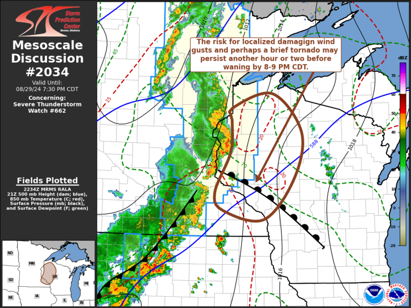
   Mesoscale Discussion 2034
   NWS Storm Prediction Center Norman OK
   0537 PM CDT Thu Aug 29 2024

   Areas affected...parts of eastern Minnesota and northwestern
   Wisconsin

   Concerning...Severe Thunderstorm Watch 662...

   Valid 292237Z - 300030Z

   The severe weather threat for Severe Thunderstorm Watch 662
   continues.

   SUMMARY...An organized squall line may continue to pose a risk for
   strong to severe wind gusts and, perhaps, a brief tornado or two,
   before gradually weakening across north central Wisconsin by 8-9 PM
   CDT.

   DISCUSSION...Cold surface ridging has been slow to lose influence
   across much of northern and eastern Wisconsin into Michigan and the
   adjacent Great Lakes.  Although modest destabilization is ongoing
   along the warm front east-southeast of Minneapolis into the Madison
   WI vicinity, it is not clear how much longer low-level southeasterly
   inflow will be sufficiently unstable to maintain the more organized
   segment of the squall line now in the process of advancing into
   northwestern and west central Wisconsin.  However, cyclonic
   mesoscale lower/mid-level circulations still evident within the line
   might maintain a risk for damaging surface gusts and perhaps a brief
   tornado or two another couple of hours, into the 00-01Z time.  Given
   the 30-35+ kt northeasterly/easterly forward propagation, this risk
   may spread into portions of north central Wisconsin east of the
   severe weather watch area.  However, it is not yet clear that a new
   severe weather watch will be needed.

   ..Kerr.. 08/29/2024

   ...Please see www.spc.noaa.gov for graphic product...

   ATTN...WFO...DLH...ARX...MPX...

   LAT...LON   45929231 46189231 46499110 45689024 44709048 43859137
               44049255 44419279 45279233 45929231
|
|
Top/All Mesoscale Discussions/Forecast Products/Home
|
|


 @NWSSPC