|
| Mesoscale Discussion 2029 |
|
< Previous MD Next MD >
|
|
Mesoscale Discussion 2029
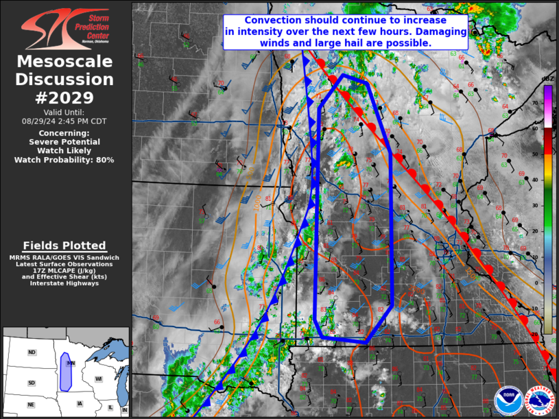
NWS Storm Prediction Center Norman OK
1240 PM CDT Thu Aug 29 2024
Areas affected...Portions of western into central Minnesota
Concerning...Severe potential...Watch likely
Valid 291740Z - 291945Z
Probability of Watch Issuance...80 percent
SUMMARY...Storm coverage and intensity will increase this afternoon
in western/central Minnesota. Some initial storms will be
supercellular and be capable of large hail and damaging winds.
Somewhat rapid upscale growth is expected which will transition the
primary threat to damaging winds later this afternoon. A watch is
likely in the next 1-2 hours.
DISCUSSION...Visible satellite/mosaic radar imagery shows a steady
increase in convection along/ahead of a cold front near the western
Minnesota border. As temperatures continue to warm into the low/mid
80s in west-central/southwest Minnesota, MLCIN will continue to
erode and convection should intensify with time and likely expand in
coverage as well. Damaging winds will be possible as will large
hail. The large hail potential may be maximized farther north where
shear is stronger and the mode may remain discrete longer. Though
the tornado risk will not be zero, the stronger 850 mb winds are
expected to translate eastward with time and the larger low-level
SRH should reside closer to the slowly lifting warm front within the
Mississippi Valley. The tornado threat is expected to be greater
farther east. The main uncertainty is how long a discrete mode will
be maintained (most guidance shows relatively quick upscale growth
along the front) and when storms will become severe. The current
thinking is that a watch will be needed in the next 1-2 hours.
..Wendt/Guyer.. 08/29/2024
...Please see www.spc.noaa.gov for graphic product...
ATTN...WFO...DLH...MPX...FGF...FSD...
LAT...LON 43909606 47139599 47659547 47529493 46469442 44129441
43569496 43639590 43909606
|
|
Top/All Mesoscale Discussions/Forecast Products/Home
|
|


 @NWSSPC