|
| Mesoscale Discussion 2028 |
|
< Previous MD Next MD >
|

|
   Mesoscale Discussion 2028
   NWS Storm Prediction Center Norman OK
   1220 PM CDT Thu Aug 29 2024

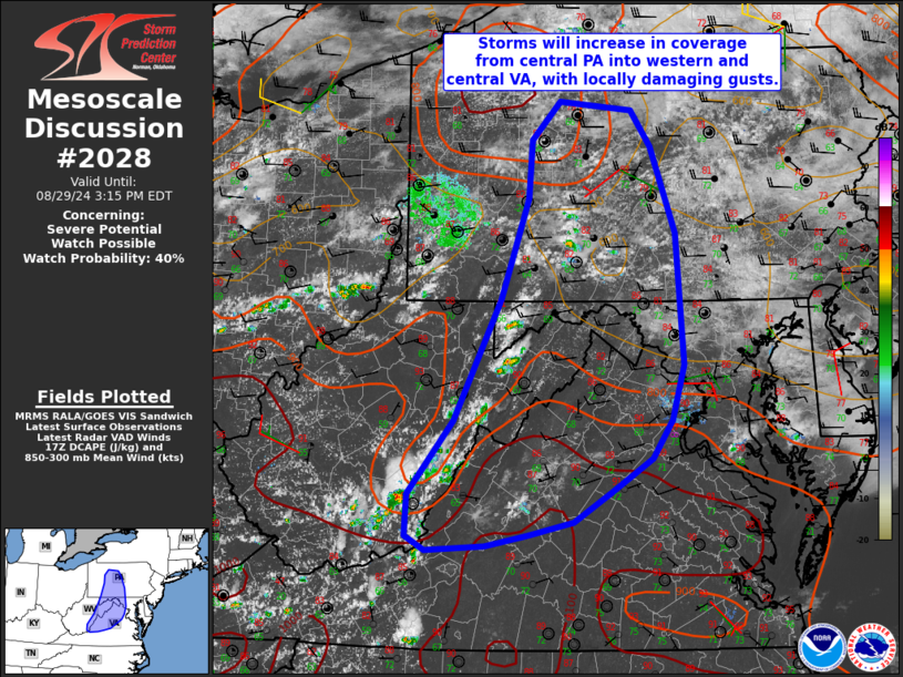
   Areas affected...central Pennsylvania into western and central
   Virginia

   Concerning...Severe potential...Watch possible

   Valid 291720Z - 291915Z

   Probability of Watch Issuance...40 percent

   SUMMARY...Scattered storms will develop from central Pennsylvania
   southwestward along the Blue Ridge, with locally strong to damaging
   gusts possible into surrounding areas to the east later today.

   DISCUSSION...A moist and unstable air mass is in place today south
   and west of the New England surface ridge, and despite slow drying
   from the east. Visible imagery clearly indicates a very moist air
   mass with expansive cumulus fields over much of PA and southwestward
   along the Blue Ridge. GPS PWAT sensors show values of 1.75-2.00"
   from eastern VA/DelMarVa northwestward into central PA.

   Continued heating will lead to accelerated development over the
   higher terrain of eastern WV and western VA over the next few hours,
   with additional activity expected over much of central PA where weak
   convergence exists. Shear will remain weak over most of the area,
   with propagating clusters of storms expected to move east/southeast
   into the remainder of central and northern VA and parts of MD.
   Locally damaging gusts will be possible given the favorable timing
   of the development with peak heating, and as outflow pushes into
   regions with steep low-level lapse rates later this afternoon.

   ..Jewell/Guyer.. 08/29/2024

   ...Please see www.spc.noaa.gov for graphic product...

   ATTN...WFO...AKQ...CTP...LWX...RNK...PBZ...RLX...

   LAT...LON   37588049 37968048 38637995 39737939 40667907 41197904
               41537871 41457786 41137764 40337735 39147726 38647739
               38287763 37997810 37707854 37587908 37487957 37448026
               37588049
|
|
Top/All Mesoscale Discussions/Forecast Products/Home
|
|


