|
| Mesoscale Discussion 2030 |
|
< Previous MD Next MD >
|
|
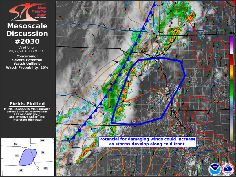
   Mesoscale Discussion 2030
   NWS Storm Prediction Center Norman OK
   0235 PM CDT Thu Aug 29 2024

   Areas affected...Eastern Nebraska into western Iowa

   Concerning...Severe potential...Watch unlikely

   Valid 291935Z - 292130Z

   Probability of Watch Issuance...20 percent

   SUMMARY...Storm coverage along the cold front should continue to
   increase in eastern Nebraska and eventually western Iowa. The slow
   push eastward of storms and potential for outflow does increase
   uncertainty in how organized the damaging wind threat will be.
   Trends will be monitored, but a watch is not expected currently.

   DISCUSSION...Convection has developed along the cold front in
   south-central Nebraska. Additional storms are likely to develop
   along the boundary through the afternoon given the destabilization
   (particularly southeast Nebraska) evident on visible satellite. With
   shear vectors roughly parallel to the front, storm mode should be
   decidedly linear. It is possible for a supercell or two to be
   embedded in the line, especially with northern extent. The main
   hazard should be damaging winds with isolated large hail more
   conditional on a discrete storm mode.

   In northwest Iowa and south-central Nebraska, outflow from
   convection is evident on KFSD/KUEX radar imagery. With similar
   potential for outflow pushing away from storms and the frontal
   motion continuing to the east, there is some chance many storms will
   be slightly elevated in nature and for corridors of greater wind
   damage potential to be dependent on mesoscale outflow surges.

   ..Wendt/Guyer.. 08/29/2024

   ...Please see www.spc.noaa.gov for graphic product...

   ATTN...WFO...DMX...FSD...OAX...GID...

   LAT...LON   40109890 40549876 42149800 42319785 42559754 42649631
               42499533 41939512 40319637 40069746 40069806 40109890
|
|
Top/All Mesoscale Discussions/Forecast Products/Home
|
|


 @NWSSPC