|
| Mesoscale Discussion 2027 |
|
< Previous MD Next MD >
|
|
Mesoscale Discussion 2027
NWS Storm Prediction Center Norman OK
1247 AM CDT Thu Aug 29 2024
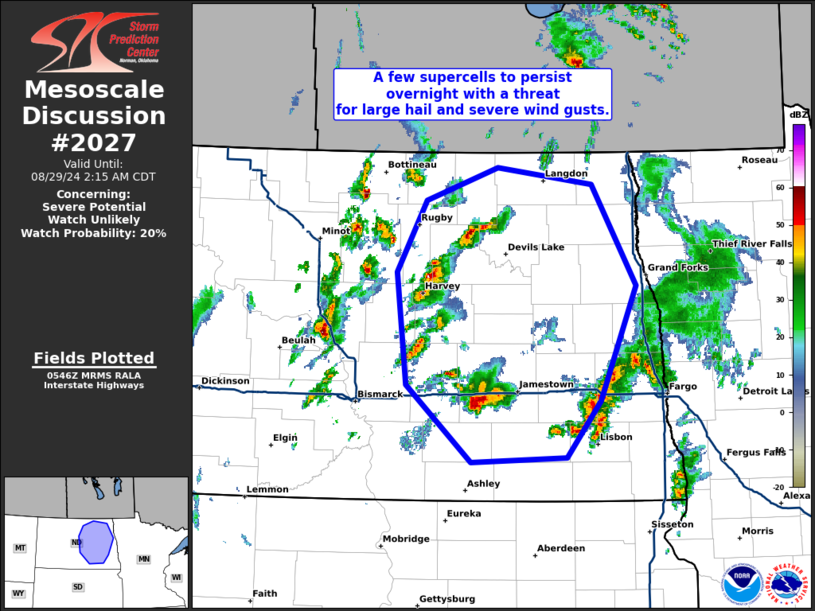
Areas affected...central and eastern North Dakota
Concerning...Severe potential...Watch unlikely
Valid 290547Z - 290715Z
Probability of Watch Issuance...20 percent
SUMMARY...A few supercells across central North Dakota are expected
to persist into eastern North Dakota early this morning with a
threat or isolated large hail and severe wind gusts.
DISCUSSION...Regional radar composite shows a decaying MCS across
southeast North Dakota as this cluster moves east of the better
instability. Across western and central North Dakota, a significant
increase in convection has occurred during the last hour within the
post-frontal airmass due to a combination of strengthening
isentropic ascent and DCVA ahead of the approaching mid-level
trough. Between this post-frontal convection and the decaying MCS a
locally favorable environment exists. MUCAPE around 2000 to 3000
J/kg on the apex of a strengthening low-level jet and strong shear
(50-60 knots per BIS VWP) will support strong to severe supercells.
While this environment will be quite favorable for the next 1 to 2
hours, expect storms to quickly outpace this better environment and
thus weaken across eastern/northeast North Dakota. Due to the
limited temporal nature of the threat, no severe thunderstorm watch
is justified.
..Bentley/Edwards.. 08/29/2024
...Please see www.spc.noaa.gov for graphic product...
ATTN...WFO...FGF...BIS...
LAT...LON 46279930 46950013 47950026 48579988 48869896 48729772
47839716 46819762 46319806 46279930
|
|
Top/All Mesoscale Discussions/Forecast Products/Home
|
|


 @NWSSPC