Mesoscale Discussion 2026
NWS Storm Prediction Center Norman OK
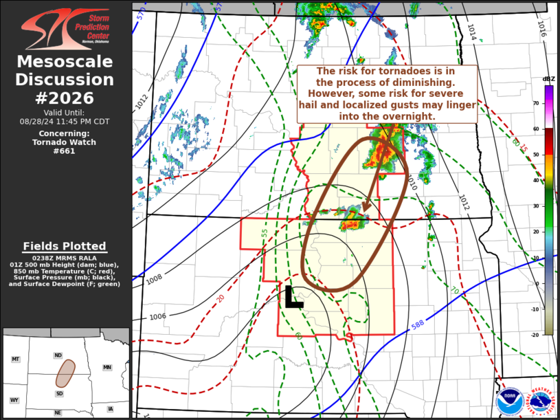
0941 PM CDT Wed Aug 28 2024
Areas affected...parts of north central South Dakota and south
central North Dakota
Concerning...Tornado Watch 661...
Valid 290241Z - 290445Z
The severe weather threat for Tornado Watch 661 continues.
SUMMARY...Thunderstorm development, in general, is beginning to
weaken, with the risk for tornadoes likely to become increasingly
negligible through 10-11 PM CDT. Some risk for severe hail and,
perhaps, localized strong wind gusts may persist into the overnight
hours across parts of the central and eastern Dakotas. However, a
new severe weather watch is not currently anticipated.
DISCUSSION...Ongoing convection appears to be undergoing notable
weakening trends, including the the isolated supercell just south of
the state border vicinity, across eastern Campbell county South
Dakota. This has occurred as the loss of daytime heating has
resulted in increasing inhibition for the seasonably moist boundary
parcels near the surface trough across the central Dakotas.
However, forcing associated with strong low-level warm advection may
maintain at least a severe hail threat with the Campbell county
storm as it accelerates north-northeastward, and becomes
increasingly rooted above the boundary layer during the next hour or
two.
Strongest potential instability remains focused near a weak surface
low, centered within the surface trough to the north-northwest of
Pierre SD. However, as the slow moving upstream low, now centered
over southern Saskatchewan just to the north of the international
border, continues east-northeastward, models suggest that warming
elevated mixed-layer air will gradually advect across the central
North and South Dakota state border area through 04-05Z. As this
occurs, the potential for renewed thunderstorm development rooted
within the unstable boundary layer is expected to diminish.
..Kerr.. 08/29/2024
...Please see www.spc.noaa.gov for graphic product...
ATTN...WFO...ABR...BIS...
LAT...LON 45960044 47149937 46599839 45019952 45030058 45960044
|


 @NWSSPC