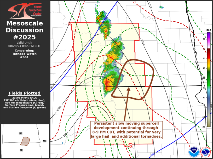
   Mesoscale Discussion 2025
   NWS Storm Prediction Center Norman OK
   0652 PM CDT Wed Aug 28 2024

   Areas affected...parts of north central South Dakota and south
   central North Dakota

   Concerning...Tornado Watch 661...

   Valid 282352Z - 290145Z

   The severe weather threat for Tornado Watch 661 continues.

   SUMMARY...Supercell development likely will persist near the Dakotas
   state border vicinity between Jamestown ND and Mobridge SD through
   8-9 PM CDT.  These storms will pose a continuing risk for large hail
   in excess of 2 inches in diameter, with at least some further
   increase in tornadic potential possible.

   DISCUSSION...Intense thunderstorm initiation has been focused along
   surface troughing across the central Dakotas, most notably near and
   just north of the state border vicinity.  This is near the nose of
   stronger surface heating characterized by temperatures approaching
   90 F, in the presence of lower/mid 70s F dew points. Coupled with
   forcing for ascent, this has been sufficient to overcome mid-level
   inhibition associated with warm and capping elevated mixed-layer
   air.

   At least some attempt at upscale growth is underway north of the
   sustained supercell development to the southwest of Fort Yates,
   across and north of the Bismarck vicinity.  However, the mid-level
   cold core of the slow moving upstream low, progressing eastward
   along the central Montana international border area, will remain
   displaced well to the west of the weak southeastward advancing cold
   front.  Strongest low-level forcing, in the form of
   lower/mid-tropospheric warm advection, appears likely to remain
   focused near the North and South Dakota state border area, between
   Jamestown ND and Mobridge SD, aided by an intensifying southerly
   low-level jet (to 50+ kt around 850 mb) through 01-02Z.

   This probably will maintain evolving supercell structures, perhaps
   within a small upscale growing cluster.  Aided by southeasterly
   inflow of air characterized by CAPE in excess of 3000-4000 J/kg, in
   the presence of moderate southwesterly deep-layer shear, activity
   will continue to pose a risk for large hail.   As clockwise-curved
   low-level hodographs slowly enlarge, the potential for tornadoes may
   still increase a bit further early this evening.

   ..Kerr.. 08/28/2024

   ...Please see www.spc.noaa.gov for graphic product...

   ATTN...WFO...ABR...BIS...

   LAT...LON   45870028 46719973 46469867 45609907 45609975 45640042
               45870028
|


 @NWSSPC