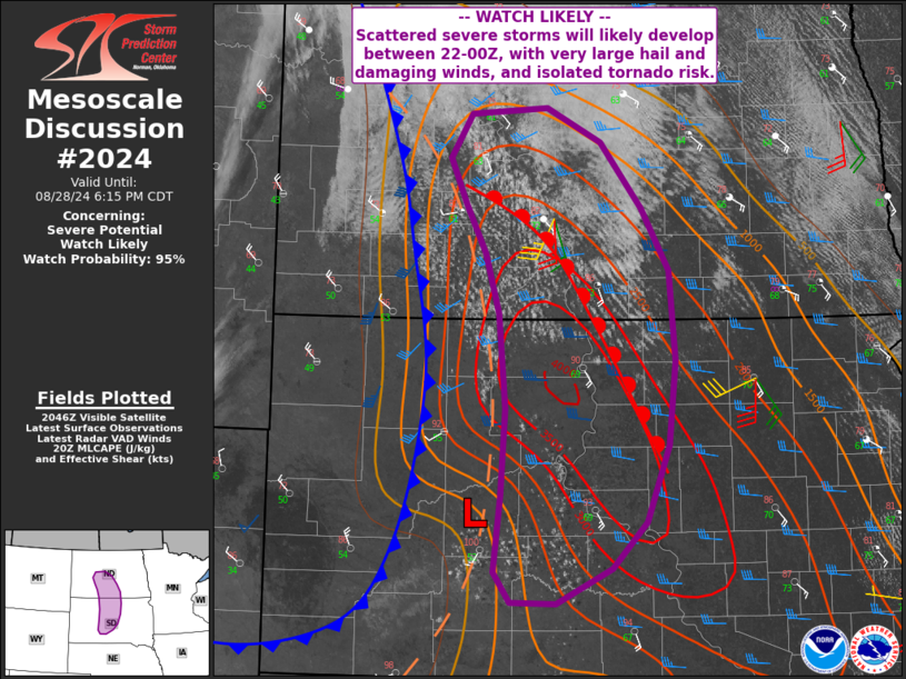
   Mesoscale Discussion 2024
   NWS Storm Prediction Center Norman OK
   0351 PM CDT Wed Aug 28 2024

   Areas affected...north-central South Dakota into North Dakota

   Concerning...Severe potential...Watch likely

   Valid 282051Z - 282315Z

   Probability of Watch Issuance...95 percent

   SUMMARY...Scattered severe storms are likely to develop over the
   next couple hours, with very large hail, damaging gusts, and a
   tornado or two expected.

   DISCUSSION...Surface analysis shows a low over west-central SD, with
   a pre-frontal trough extending northward into western ND. A cold
   front continues to surge eastward across the western Dakotas,
   enhancing low-level convergence.

   Meanwhile, a warm front currently extends from near Bismarck into
   northeast SD, with upper 60s to near 70 F dewpoints nearby. The
   combination of daytime heating and the moist air mass had led to a
   pocket of strong destabilization with several thousand MUCAPE
   despite mediocre midlevel lapse rates.

   Visible imagery show rapidly develop cumulus fields in the warmer
   air near the surface low, and farther north into central ND where
   convergence is maximized along the boundaries. Given the continued
   heating and convergence, storms are expected to form within the next
   couple hours.

   Veering winds with height along with the approaching upper trough
   will favor slow-moving supercells at first, producing very large
   hail and perhaps a tornado or two. With time, a linear storm mode is
   likely with damaging winds.

   ..Jewell/Guyer.. 08/28/2024

   ...Please see www.spc.noaa.gov for graphic product...

   ATTN...WFO...ABR...BIS...UNR...

   LAT...LON   43870145 44490137 45210132 45990140 46470156 46870179
               47250198 47610172 47670083 47390020 46849972 46349940
               45599934 44909942 44279968 43900007 43600073 43610126
               43870145
|


 @NWSSPC