|
| Mesoscale Discussion 2019 |
|
< Previous MD Next MD >
|

|
   Mesoscale Discussion 2019
   NWS Storm Prediction Center Norman OK
   0516 PM CDT Tue Aug 27 2024

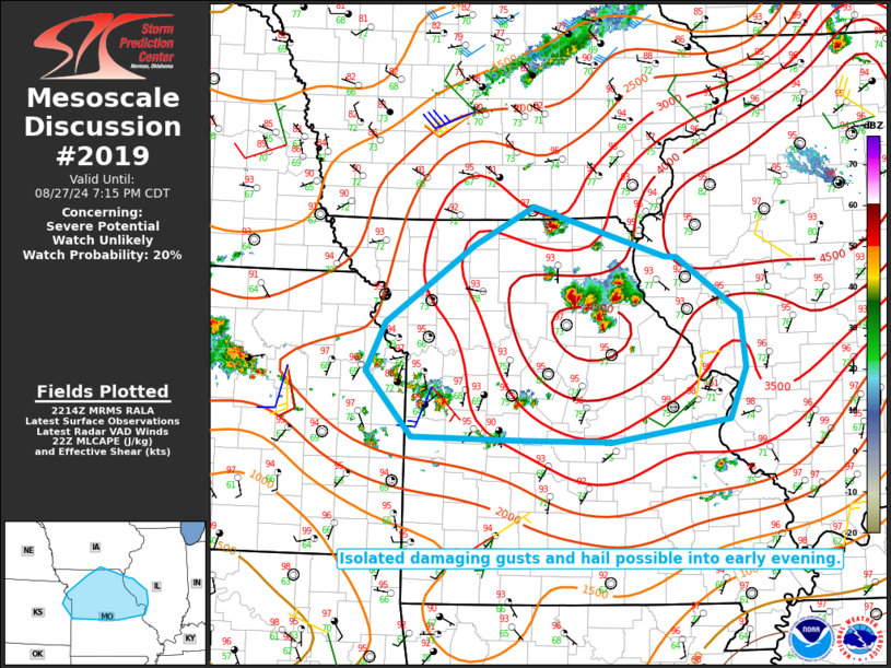
   Areas affected...Extreme northeast KS into central/northern MO and
   western IL

   Concerning...Severe potential...Watch unlikely

   Valid 272216Z - 280015Z

   Probability of Watch Issuance...20 percent

   SUMMARY...Isolated damaging gusts and hail are possible into early
   evening.

   DISCUSSION...Isolated thunderstorms have developed from
   south/southeast of Kansas City into northern MO. The environment
   across this region is quite warm, moist, and unstable, with MLCAPE
   of 2500-4000 J/kg in place. However, deep-layer flow and vertical
   shear are generally weak, which should tend to limit storm
   organization.

   Given the favorable instability and rather steep low/midlevel lapse
   rates, the strongest updrafts could briefly pose some hail threat,
   though localized downbursts may become the most prominent hazard
   with time. This isolated severe threat may persist into early
   evening.

   ..Dean/Gleason.. 08/27/2024

   ...Please see www.spc.noaa.gov for graphic product...

   ATTN...WFO...ILX...LSX...DVN...SGF...DMX...EAX...TOP...

   LAT...LON   39479490 40309368 40729288 40199108 40189091 39589006
               39008998 38459021 38219179 38239303 38269453 38969515
               39479490
|
|
Top/All Mesoscale Discussions/Forecast Products/Home
|
|


