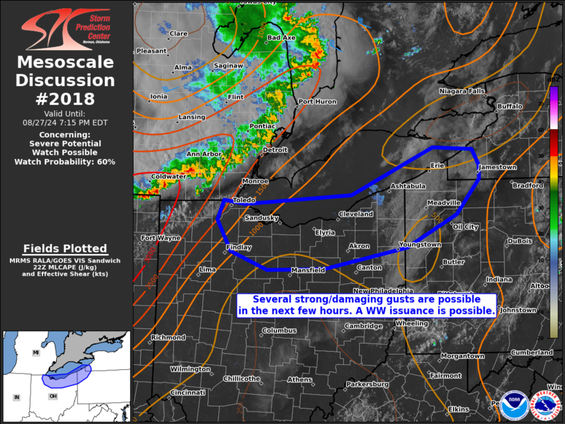
   Mesoscale Discussion 2018
   NWS Storm Prediction Center Norman OK
   0511 PM CDT Tue Aug 27 2024

   Areas affected...portions of northern Ohio into extreme northwestern
   Pennsylvania and extreme southwestern New York

   Concerning...Severe potential...Watch possible

   Valid 272211Z - 272315Z

   Probability of Watch Issuance...60 percent

   SUMMARY...The severe threat should increase over the next few hours
   as an organized line of strong to severe thunderstorms approaches.
   Damaging gusts are the primary concern. A Severe Thunderstorm Watch
   may be needed soon.

   DISCUSSION...A persistent elongated convective system, with a
   history of strong to severe wind gusts, continues to rapidly
   propagate southeastward due to a surging cold pool, delineated by
   -20 F observed surface temperature changes. Surface
   temperatures/dewpoints preceding the convective system have been in
   the lower 90s/lower 70s F, contributing to 2000-3500 J/kg MLCAPE
   (when considering 7+ C/km mid-level lapse rates). However, surface
   temperatures/dewpoints and mid-level lapse rates decrease with
   east-southeastward extent, so questions remain how profound the
   severe threat will become after the convective system crosses Lake
   Erie. Nonetheless, considerable momentum associated with the cold
   pool suggests that at least some organized damaging wind threat
   should persist as storms move ashore. Furthermore, the lack of
   friction over the water surface may allow for the generation of
   considerable kinematic momentum, with particularly strong/damaging
   gusts likely along the Lake Erie shoreline.

   With an appreciable threat of strong/damaging gusts evident, a
   Severe Thunderstorm Watch may be needed soon.

   ..Squitieri/Gleason.. 08/27/2024

   ...Please see www.spc.noaa.gov for graphic product...

   ATTN...WFO...BUF...CTP...PBZ...CLE...DTX...

   LAT...LON   42007920 41547961 41128048 40848192 40828290 41068354
               41478378 41728368 41688330 41808144 42428002 42407932
               42197920 42007920
|


 @NWSSPC