|
| Mesoscale Discussion 2010 |
|
< Previous MD Next MD >
|
|
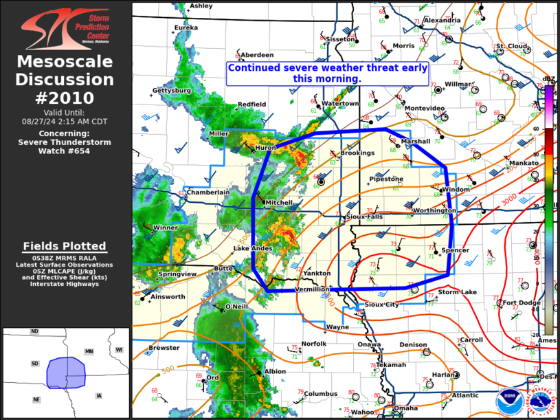
   Mesoscale Discussion 2010
   NWS Storm Prediction Center Norman OK
   1241 AM CDT Tue Aug 27 2024

   Areas affected...southeast South Dakota...southwest Minnesota...and
   northwest Iowa.

   Concerning...Severe Thunderstorm Watch 654...

   Valid 270541Z - 270715Z

   The severe weather threat for Severe Thunderstorm Watch 654
   continues.

   SUMMARY...The threat for severe storms will continue early this
   morning across southeast South Dakota, southwest Minnesota, and
   northwest Iowa.

   DISCUSSION...A few storms along the remnant outflow boundary from
   the earlier MCS have strengthened across eastern South Dakota in the
   last hour. This is a trend which may continue over the next 1 to 2
   hours as this boundary and ongoing storms advance toward an
   increasingly unstable airmass. Given the strengthening which has
   already occurred amid ~1000 J/kg MLCAPE and mid to upper 60s
   dewpoints, expect additional strengthening as storms move into low
   70s dewpoints and only weak inhibition north of the surface low
   across southeast South Dakota, northwest Iowa, and potentially
   southwest Minnesota.  Severe gusts will be the primary threat, but
   at least some large-hail threat will persist as any storms remain
   more discrete/supercellular.

   Eventually, storms will move ahead of the better shear (near the
   eastern bounds of watch 654) which will likely bring an end to the
   more organized severe weather threat. However, in the interim, a
   favorable environment remains for a few potentially potent severe
   storms.

   ..Bentley.. 08/27/2024

   ...Please see www.spc.noaa.gov for graphic product...

   ATTN...WFO...MPX...FSD...OAX...ABR...

   LAT...LON   42719794 42979819 43819821 44419793 44599718 44659602
               44499560 44179503 43509493 42909501 42759571 42719794
|
|
Top/All Mesoscale Discussions/Forecast Products/Home
|
|


 @NWSSPC