|
| Mesoscale Discussion 1996 |
|
< Previous MD Next MD >
|
|
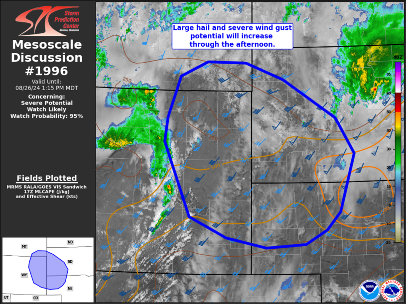
   Mesoscale Discussion 1996
   NWS Storm Prediction Center Norman OK
   1215 PM CDT Mon Aug 26 2024

   Areas affected...northeast WY...southeast MT...western SD...and
   western NE

   Concerning...Severe potential...Watch likely

   Valid 261715Z - 261915Z

   Probability of Watch Issuance...95 percent

   SUMMARY...Severe thunderstorm potential will increase over the next
   few hours across eastern Wyoming into far southeast Montana, western
   South Dakota and western Nebraska. Large hail and severe wind gusts
   possible with this activity. A severe thunderstorm watch will likely
   be needed for portions of the region in the next couple of hours.

   DISCUSSION...A strong mid/upper trough will continue to eject
   east/northeast across WY/MT this afternoon, providing ample
   large-scale ascent for thunderstorm development. Boundary-layer
   moisture will remain modest, but cool temperatures aloft/steep lapse
   rates will foster MLCAPE from 1000-2000 J/kg. Effective shear
   greater than 40 kt will favor organized updrafts, with a mix of
   supercells and line segments possible. Elongated/straight hodographs
   combined with a favorable thermodynamic and kinematic environment
   will support large hail, with some potential for isolated hail
   stones in the 2-3 inch diameter range in the strongest cells.
   Additional heating will result in steepening low-level lapse rates,
   enhancing severe gust potential, particularly across parts of
   eastern WY into far southwest SD and northwest NE, where a few gusts
   greater than 70 mph are possible.

   Some uncertainty exists on the north/east extent of severe potential
   as morning convection across central SD has left lingering cloud
   cover while reinforcing a more southward position of a surface
   baroclinic zone near the SD/NE border. Nevertheless, a severe
   thunderstorm watch will likely be needed for portions of the MCD
   area within the next couple of hours.

   ..Leitman/Guyer.. 08/26/2024

   ...Please see www.spc.noaa.gov for graphic product...

   ATTN...WFO...LBF...UNR...CYS...BYZ...RIW...

   LAT...LON   44420658 45310621 45620539 45600423 45250310 44400151
               43620098 42350143 41960182 41650245 41570361 41790478
               42240588 43870665 44420658
|
|
Top/All Mesoscale Discussions/Forecast Products/Home
|
|


 @NWSSPC